| |
| |
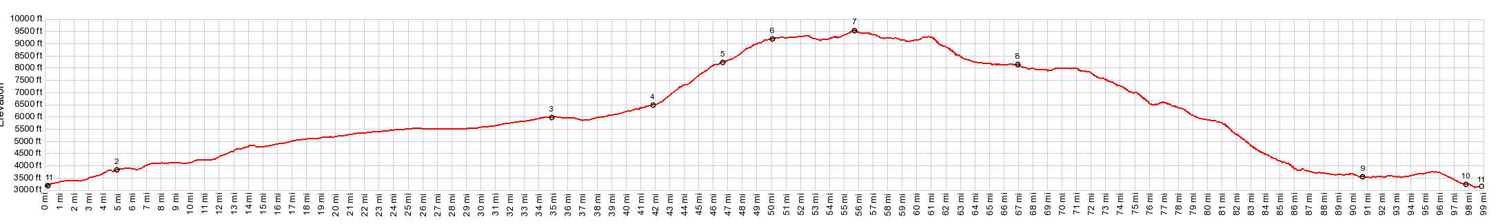
Kolob Terrace s(u)
These are two understandably
popular, paved climbs, connected by a rolling dirt
road over the top of a high plateau. In the
process the road climbs almost 6 thousand feet
between the high and low points of the profile.
But it does so in stages. Along the way are some
of the more remote vistas of Zion National Park,
that can still be seen from a road, and more,
different landscapes of colorful cliffs to the
north.
In Cedar City the profile enters the colorful
rocks of Cedar Canyon - a fairly busy road on a
weekend. But it is about to get better with the
turnoff onto Right Hand Canyon Road. The signs and
the turnoff are easily overlooked, even on a
bicycle. This curvy, but wide road with very
little traffic climbs up the Cedar Mountains in
the Hurricane Cliffs, and soon the word "colorful"
makes much more sense. Quickly the panorama also
takes in the lower ranges to the west and the man
made grid of the world below. There is a trailhead
parking lot to the C - Trail with 270 degrees of
clear crisp panorama. The trail is open to
mountain bikes. But this profile climbs higher on the main road.
The Mac Mansions of Cedar Highlands, which were
just immediately below also become toy boxes with
more climbing. The road finally climbs above a
black lava field of angular blocks and reaches the
plateau. Several more miles of rolling hills go by
until the pavement ends and the ride becomes a
fast roll on a good hard dirt road. Yet another section starts when the trees end and
the surroundings become a sweeping grass land. The
road makes some wild detours in order to avoid
exorbitant elevation differences by crossing
canyons. The high point is reached at a 90 degree
turn between two long straight sections. In the
distance the cliffs of Cedar Breaks look like the
landscape has frayed into orange at a rupture. It
is practically at eye level 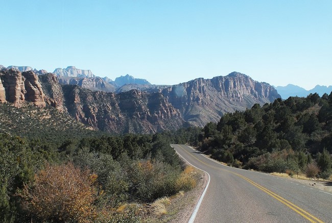 From West -2. (described
downwards) Several dips and curves lead past
another scenic lava field, this time on the
eastern end of the plateau, and then the road
starts an extended fast downhill to Kolob
Reservoir. While up until now the road has been
mostly smooth, this last section of nonpaved road
is quite a bit rougher, and I am glad I had my
Klein Mantra instead of what is now marketed as a
gravel bike. Kolob Reservoir is a pleasant lake, in a bleak
high plain, compared to all the magnificent vistas
that are not far away from here. Pavement starts
here and with that a long descent. The more
interesting and also steeper longer descends are
actually closer to the bottom. The last section of the profile on Ut9 is easily
underestimated, or maybe that's just me. It takes
time too, even if it does loose another 500ft
Dayride with this point as highest summit: PARTIALLY PAVED / UNPAVED ( < Cedar Breaks s(u) | Kolob Canyon(ow) > ) Kolob Terrace s(u) : a short way up E High Cedar Highland Dr > down E High Cedar Highland Dr > Cedar City > Ut14 east > up Right Hand Canyon Rd > up Kolob Rd > Kolob Terrace s(u) > Kolob Reservoir > down Kolob Reservoir Rd > Ut9 west > Ut17 north > La Verquin > Toquerville > Anderson Jct > I15 north > Cedar City > back up E High Cedar Highland Dr to starting point: 103.3miles with 8500ft of climbing in 9:20hrs (Garmin etrex30 m3:19.10.12) (pics: t19_38:1-37) Notes: I had a flat on I15 just before sunset. There was still plenty of light to fix the flat. But the last 12 miles were in darkness with a full moon - otherwise perfect conditions. 4 miles are due to the out and back to the starting point of the loop .
|
|
|
advertisement |
|
|
advertisement |