| |
| |
Silver State Trail: section Bristol
Lake - Bennett Pass This part of the Silver
State Trail is difficult to ride on a
regular mountain bike because of often
sandy ground. I think a fat tire bike
would be better. The ride over this summit
is probably the slowest almost 50 mile
double track ride I have ever done for
that reason (at least with this little
elevation gain). But, speaking strictly
for myself, the reason to do it is not
lessened by this. The dessert scenery
makes this an absolutely fascinating
place. There is a dry lakebed: Bristol
Lake in Dry Lake Valley, and dessert
mountains, ressembling tire tracks
amplified in scale by the millions
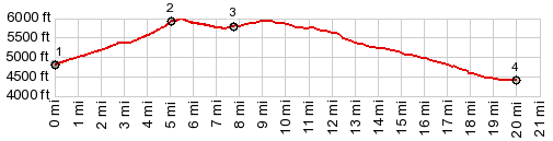
Before reaching the summit the
road turns west again. There is a short
sidetrack to a hill on the west side, with
great views all around. Some of the pictures
were taken on this short detour. From
North. (described downwards)
Conditions remain sandy over the top. The
road changes direction periodically, and it
may become unclear if the destination is
actually the Panaca area of the Caliente
area. At the next intersection with a wider
and somewhat easier ridable dirt road
(signed 15?) you have the choice of either
destination: Panaca or Caliente. The route
down Antelope Canyon to Caliente has a
larger elevation loss. But the route of the
signed Silver State Trail turns left towards
Panaca. It descends over periodically sandy
stretches to a low point ~400ft below the
summit, before turning right onto a smaller
track to Bennett Pass.
Dayride with this point
as highest summit: COMPLETELY UNPAVED: ( < Silver State Trail: section Bennett Pass - Stampede Pass | Beaver Canyon summit s(u)-1 > ) Silver State Trail: section Bristol Lake - Bennett Pass , Bennett Springs Rd s(u) : starting point between Panaca and Bennet Springs Rd s(u) at ~4750ft > Bennett Springs Rd s(u) > down road in westerly direction as possible > south down Monument Canyon > from south end of Bristol Lake up road heading west then north > Silver State Trail: section Bristol Lake - Bennett Pass > Rte 15(?) north > Rte 17(?) north > Bennett Pass(shp) > back to starting point down road to Panaca: 48.4miles with 3870ft of climbing in 6:45hrs (garmin etrex30: m3:22.5.22) Notes: Bennett Pass is only a shoulder point on this route. It does reach a 300ft drop between adjacent high points, but there is no way to make it into a 500ft drop, even if there was a way to join the other side of the profile. |
|
|
advertisement |
|
|
advertisement |