| |
| |
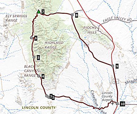
Manhattan Gap s(u) The Silver State Trail is technically an ATV trail designation. But this section at least, is mostly a good gravel road, except where noted, before the summit on the south side. The high section of the road looks out over some fantastic dessert scenery. I didn't meet a single vehicle of any type on the unpaved section of this profile, but instead many wild horses in the area around Bennett Pass. There are generally no signs at
any of the intersections, making the description
a little difficult. There are however small
arrow signs, that mark turnoffs following the
Silver State Trail. But some of these are
ambiguous.
It is a low approach rolling over
badlands, with further picturesque rock monuments
nearby. This road appears to reach a pass. Roads
crossing at the pass are signed with small "Silver
State Trail" signs in both directions. According
to the map, the official Bennett Pass is just
south of here. But the profile goes right onto a
good, straight unpaved road, climbing further
along the western flank of the Highland Range.
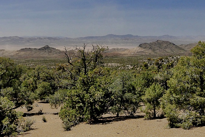
This traverse contains some magnificent views onto
Dry Lake Valley. Of the many mines marked on the
map, only one contains structures, that are
visible from the road. There are several
opportunities to branch off this road and descend
into Dry Lake Valley. All of these are possible
shoulder summits for smaller loop rides. Miles later the main road traversing
along the ridge sofar, also turns down into the
valley. But continuing the traverse is also
possible, albeit on a much smaller, wavier track.
This is what the profile does. At the junction
this route is signed with the Silver State Trail
logo. Progress slows down considerably here, and
then again more on the last section approaching
the top, as the road weaves around many mountain
coves. On these handfull of miles before the
summit, a mountain bike would be better companion.
In my case it probably wouldn't matter, because I
would walk the many extremely short steep sections
with either bike. Note that the road traversing along
the ridge does not show up on Komoot on the linked
Nevada Map page. It will show up, changing the map
selection to "National Geographic". But finally the road reaches a high
unsigned pass, not far from a spot labeled
"Manhattan Gap" on maps. Here it meets up with a
larger dirt main road, connecting Stampede Gap,
further up in the Bristol Range with the valley to
the east. At this junction the profile turns east,
down to the right.
From North. (described
downwards). The wide dirt road has fairly deep
sand, and in places is a true pain to negotiate.
But it's downhill, and it eventually meets up with
Nv320, which is about as little traffic on a paved
road as most people will ever see in their life.
You could continue on unpaved roads at this
junction. But why toture yourself any longer. The
profile chooses to head back south direction
Panaca on pavement, and meet up with the starting
point of the profile on US93.
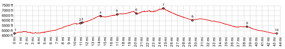
Dayride with this point as
highest summit:
PARTIALLY PAVED / UNPAVED ( < Panaca Summit | Silver State Trail, section: Bristol Lake - Bennett Pass > ) Silver State Trail: section Bennett Pass - Stampede Pass(sh) , additional out and back: Nv319, east pf Panaca at ~5600ft > Nv319 west > Airport Rd west > Bennett Springs Rd west > apr location of Bennett Pass > Silver State Trail rd north <> out and back to dead end in mountains > Silver State Trail: section Bennett Pass - Stampede Pass(sh) > unsigned road down east side of the gap > Nv320 south > US93 south > Panaca > Nv319 east back to starting point:58.3miles with 5020ft of climbing in 6:41hrs (garmin etrex30 m3:22.5.20) |
|
|
advertisement |
|
|
advertisement |