| |
| |
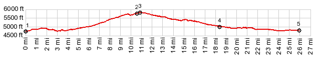
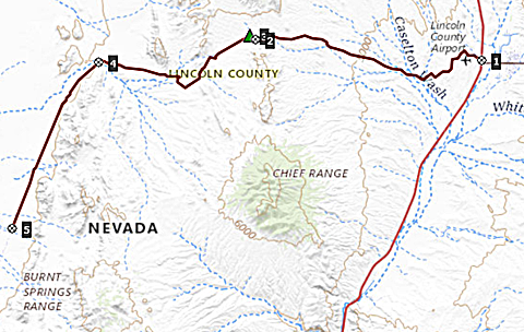
Bennett Springs Rd s(u)
This is the main gravel road
summit between Panaca and Dry Lake Valley,
containing the remnants of Bristol Lake. The east
side is common to a whole array of small dessert
summits in this area, many much sandier than the
approach on this road.
The road takes the scenic option and
often follows small ravine ridges, that allow to
survey the amazing landscape. This side is much
easier to ride than the sandy conditions of the
other side, or many other roads in this area. This
approach is the major access route towards the
west for all these other smaller sandier
tracks. During the three times I rode it, I
ran into (not literally) wild horses every time.
The highest point is an intersection with a good
road heading north towards Manhattan
Gap s(u), a short connection to Bennett Pass,
and the descend described below.
A Dayride with this point as
intermediate summit is on page: Silver
State Trail: section Bristol Lake - Bennett Pass
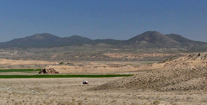 |
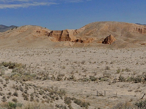 From West. (described
downwards) As the road descends between stark
dessert knolls, conditions become sandier. The
problem is not so much long sandy stretches, but
generally unfirm ground. You never know if it is
going to give way to 2.2 inch tires until they are
stuck in them. A fat tire bike would fare much
better. There are several options to reach the
white blowing salt shores of Bristol Lake. The
profile takes the most westerly, direct approach.
From there a road following along between two
power lines, that is much easier to ride follows
the lake shore south. I included some pictures
from that section also.
From West. (described
downwards) As the road descends between stark
dessert knolls, conditions become sandier. The
problem is not so much long sandy stretches, but
generally unfirm ground. You never know if it is
going to give way to 2.2 inch tires until they are
stuck in them. A fat tire bike would fare much
better. There are several options to reach the
white blowing salt shores of Bristol Lake. The
profile takes the most westerly, direct approach.
From there a road following along between two
power lines, that is much easier to ride follows
the lake shore south. I included some pictures
from that section also.|
|
advertisement |
|
|
advertisement |