| |
| |
Henderson Summit Arriving from the more southerly
parts of Nevada, I first missed the dramatic
landscapes and the rich imagination in shapes
and forms, provided by courtesy of all those
crazy cactus species, enriching the landscapes
down there. But this northern part of Nevada has
other good points, as far as gravel biking is
concerned. This is ranching country. This means
a few more fences, but also a greater amount of
nicely surfaced dirt roads, that are fun and
fast to cycle. These roads string all those
ranches together. Gone are the days of pushing
through long sandy stretches in the blazing heat
(I hope).
A perfect surface leads up a gentle
grade. The Roberts Mountains are not much more
than a kind of crusty shell on top of the
landscape, albeit snowcovered this end of May 23.
The road climbs into juniper forest and there are
no more real views, including from the summit.
There is a spur leaving from the high point, that
I did not explore to the end.
From North. (described
downwards) A surface like this should make for a
lightning fast decent. It should and it does.
Where the road emerges from the forest into the
highest of the sagebrush, my favorite section
starts. The views are endless in three directions,
and an old historic road, very close to the old
Pony express route, gives rise to historical
visions of stagecoaches with horses, speeding
through this endless country. Solitary trees
punctuate the landscape with exclamation marks. The profile reaches a four way
intersection. None of them are marked as going
anywhere, but with a map the directions are clear.
The profile follows Roberts Creek Road south,
heading straight as a ruler to intersect with US50
at a right angle. The road is hard medalled and a
joy to speed along on. The traffic is perfect. I
saw two cars, just the right amount to provide a
cushion of safety, just in case something
completely unexpected should happen, and you are
dependent on outside help. The map shows other
short cut connections towards US50, but they don't
have a fast surface like this. Roberts Creek Road reaches a low
point before it climbs back a minute amount
towards US50. But it keeps going downhill ever so
slightly to the first possible turnoff towards
Garden Summit, heading back up north.
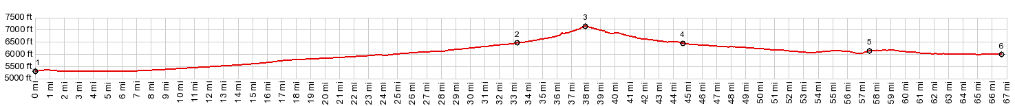
Dayride with this point as
highest summit
PARTIALLY PAVED / UNPAVED ( < FR489 Simpson Park Mtns s(u) | Bailey Pass > ) Henderson Summt , Garden Pass : near jct Garden Pass Rd - Nv278 > up Garden Pass Rd > Henderson Summit > Roberts Creek Rd south > US50 east > Collingwood Ln north > 3rd st east > Nv278 north > Garden Pass > jct Garden Pass Rd - Nv278 <> out and back on Nv278 north << with turnaround point at ~6300ft, just before turnoff to Bailey Pass >> back to starting point near jct Garden Pass Rd - Nv278: 64.2miles with 2310ft of climbing in 5:41hrs (garmin etrex32x m5:23.5.27) Notes: LOOP with short additional out and back; great weather with some favorable wind, except for a short windstorm on Nv278 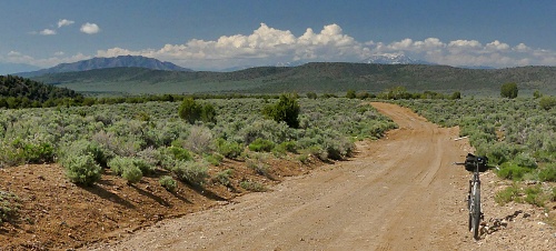 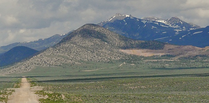  |
|
|
advertisement |
|
|
advertisement |