| |
| |
Bailey Pass This pass is short, low and sweet,
with a top that is sharp and well defined. Let
adjectives do the talking. The range it crosses
is also quite low by Great-Basin Range
standards, the Diamond Spring Range. There is a
great view from the summit, because of its
strategic location between the Roberts Mountains
and a large, mostly dry lakebed, lined by
ranches.
There are two possible routes that
turn off Nv278, that meet fairly close to Bailey
Summit. Neither of the turnoffs are signed. Both
are gated, but not locked, and easy to miss. But
they are the only two gravel roads, that head
east, when heading down from Garden Pass,
direction north. The one in the profile is the more
northerly of the two and leaves a short distance
north of the one and only house that you pass when
rolling down Garden Pass. As is often the case
around here, it first looks like the climb is
going to be over as soon as it crosses the fault
line and enters the mountains. But of course it is
not. But it certainly doesn't take very long to
get to the top. The top is extremely well defined,
and there are nice views in both directions. the
Roberts Mountains to the west and fringes of water
in Alkali Flat, invading Diamond Valley with its
salty tentacles. An ATV path from the summit heads
a little higher in both direction.
From West.
While the other side has a very bicycle friendly
surface, this side is quite a bit more rocky, and
would be difficult to ride up. When approaching
the valley, the road splits, and the main branch
climbs one more small balcony for a view over the
lake. The bottom of the approach is extremely
rutted, sandy or washed out, depending on the
current weather emergency, flood or drought, it is
usually one or the other.
 Dayride
with this point as highest summit Dayride
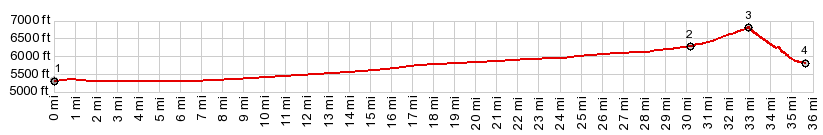
with this point as highest summitPARTIALLY PAVED / UNPAVED ( < Henderson Summit | Angel Lake(ow) > ) Bailey Pass , Garden Pass , additional out and back : jct Garden Pass Rd - Nv 278 > up unmarked gravel road going east > Bailey Pass > jct with Sadler Brown Rd <> out and back on Sadler Brown Rd north with turnaround point after ~11.3miles >> Sadler Brown Rd south > Nv278 north > Garden Pass > back to starting point at jct Garden Pass Rd - Nv278:: 51.8miles with 2380ft of climbing in 5:04hrs (garmin etrex32 m5:23.5.28) Notes: the weather this year is completely different than expected: today light rain in the desert with winter gloves weather. |
|
|
advertisement |
|
|
advertisement |