| |
| |
FR489 Simpson Park Mtns s(u) This is a rare juniper forest
summit surrounded by large bowls of Sagebrush
dessert. Still, I have to admit that my
favorite part are the lower parts through
sagebrush country, where the views are
unobstructed, but from a little higher vantage
point. That part of the road is also much
faster cycling due to the surface.
While up to this point, however
you got here, you were travelling in wide open
sage dessert country, here you are surrounded by
a forest of small juniper trees. At another
intersection with a "BLM" sign it pays to stay
right, instead of going back into the Petroglyph
area. The readily bikable double track quickly
leads to an apparent summit with somewhat of a
view to the Toyabee Mtns. However this is really
a kind of roller coaster. The third apparent
summit really is it, where the road converges
with the power lines. The view from here is less
interesting than the previous described view
somwhat lower. 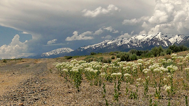 From West. At
the summit the track makes a strong bend to the
left and now becomes a power line service road.
The surface is quite variable, but generally
also quite ridable. I was here two days after a
rare heavy rain, and there was actually more mud
than sand. After an extended flat section, the
road heads up toward a transformer station. Here
the surface improves a lot. The profile goes
down the wide expanse of what is labeled Rye
Canyon and Simpson Park Canyon on the map. In
reality there are no signs (there was one sign
with a mysterious "4" on it somewhere along the
route), and the scenery is a magnificent
sweeping sage sauce pan shaped bowl, bordered in
the distance by the Toyabee Range. This part is
actually the most scenic along the entire route.
But FR489 (if that is indeed the numbetr)
continues on a smaller track across another
range, direction Grass Valley Road and Bob Scott
Summit. The profile ends at a low point on US50
in Big Smoky Valley
Dayride with this point as
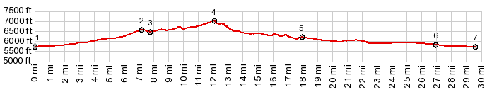
highest summit PARTIALLY PAVED / UNPAVED ( < Austin Summit | Henderson Summit > ) FR489 Simpson Park Mtns s(u) : Hickinson Summit Petropglypy area > up unmarked forest road > FR489 Simpson Parkt Mtns s(u) > down Rye Patch Canyon > vicinity of Givens Ranch > down Simpson Park Canyon > road in sw direction <> out and back to jct with Nv376 > US50 east > first unpaved road heading south > Pete's Canyon Rd east > first unpaved road heading north > US50 east > Hickinson Summit(shp) > back to Hickinson Summit Petroglyph area: 42.4miles with 2540ft of climbing in 5:12hrs (garmin etrex32 m5:23.5.25) Notes: the planned route went over a second summit to connect with Grass Valley Rd to Tom Scott Summit. But due to approaching thunderstorms and slow going on FR489 I opted for the decent into Big Smoky Valley - which was actually the best part of the ride, scenically and surface wise. Relative to the profile above, T=this loop contains a few additional miles in the valley, connecting to points south from the two endpoints. |
|
|
advertisement |
|
|
advertisement |