| |
| |
Garden Pass
If a long rural road in Nevada
runs north - south, it generally threads along one
of the many basins of Nevada. These basins are
bordered by linear fault ranges, that seem to go
on forever in the same direction. Along the way,
these north south roads sometimes also cross
summits. They are about as small as you would
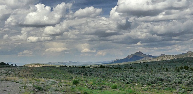
expect them to be. This one has a desolate kind of
beauty. Garden Pass, crossing between the Roberts
Mountains and the Sulphur Spring Range has very
little traffic, except maybe if special
circumstances, that cause heavy traffic on the
outskirts of Eureka. It is interesting to note,
that moderately quiet and remote as this road may
seem, the roads in the neighboring valleys to the
east and west are still more remote and largely
unpaved. Those would be Newark Valley Rd and Grass
Valley Rd.
At this point whatever traffic may
have been generated by the ranching conglomeration
near Eureka has pretty much disappeared, and the
road heads straight for its new goal, the snowy
crustations of the Roberts Mountains. Nv278
crosses the old Pony Express trail on the lower
approach. The location is signed from the road and
signs have a few interesting historical
explanations at the ready. As the top comes closer
the slope gets shallower and the trees become
abundant. From South. (described
downwards). It is not until the road begins to
descend again from this wide shallow saddle, that
a kind of view opens. On a photo you can't even
tell that there is a slope involved on this side.
It looks just like a plain with complementing rock
arches framing the scene on the outside edge of a
wide angle view. I think it has a desolate, kind
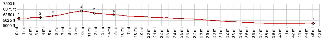
of come-what-may beauty to it. The downhill feels
about as expected, slow - but it lasts a long
time.
 |
|
|
advertisement |
|
|
advertisement |