| |
| |
Hancock Summit
Nv375 is one of those wonderful
roads, that does not really connect big or even
medium sized centers of population. It winds
through the dessert as dictated by the landscape,
in a macro kind of way. There are still stretches
of 10 to 15miles without turns. But there are
significant changes in direction between these
long straight sections. All this spells little car
traffic and great cycling conditions - and it is
even paved and does not have rumble strips. Did I
mention the outlandish dessert scenery ? November
must be one of the best months here.
From West. Even if the
road doesn't make a single degree of turn, once
the road has zeroed in on the valley, it becomes
apparent, that this is the scenic side. The reason
for this is the Pahrangat Range, which has a
decidedly more fault block type of appearance
about it, from the vantage point here in the
valley. And then there is a virtual Joshua Tree
jungle in the foreground. All this thanks to
different species of moths and their polinating
habbits, as is explained by a BLM sign in the
middle of this dessert wonderland. The lowest point is at the junction with Mail Box
Road. A well-stickered mailbox stands at the
junction. This road leads the the boundary of a
restricted area, known as Area 51. This is a
restricted area inside Nellis Air Force Range,
that has been hyped into a meeting point for UFO
seekers.
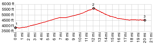
Dayride with this point as highest summit: ( < Oak Springs Summit | Pioche s(u) > ) Hancock Summit x2 , Coyote Summit x2 : ~5miles west of Crystal Springs <> Crystal Springs >> new out and back <> Nv375 west <> Hancock Summit <> Tikaboo Valley <> Coyote Summit << turnaround point at jct with dirt road ~.5miles before Rachel: 77.9miles with 4550ft of climbing in 6:17hrs Notes: late start because I had to switch rear wheels and fix a flat; return just before sundown, perfect weather and light 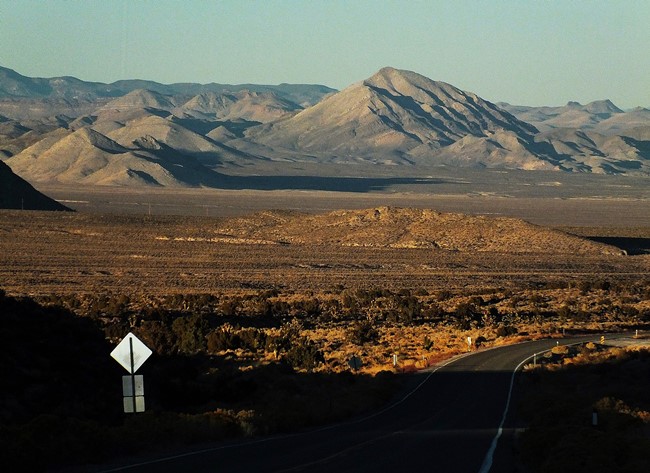 |
|
|
advertisement |
|
|
advertisement |