This high point is occupied by a
historic old mining town, that still has plenty
of signs of life, as well a great views into a
sweeping valley. I'm told Pioche was a French
miner and you don't pronounce it Peeothshy but
Pee-Yosh. This came as a surprise to me, who
first pronounced a small town in Colorado:
Lyons, something like Lee-Yong.
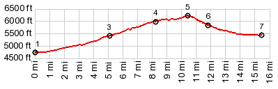
Back to the road. After a climb on the rumble
road, at its summit a side road leads into Pioche.
It traverses on what has now become a shallow but
high ridge, with sweeping views onto Lake Valley,
which I want to call a plain instead of a valley.
At the summit the old mining town comes into sight
like a life sized map. From here a foot trail
leads along an old mining tramway to a town summit
with a cross on top. The views from there are even
better. A sign along the road tells that this
tramway operated mostly by gravity. Descending
full ore carts would be heavier than the ascending
empty carts. What an ingenious system !
 From East. (described
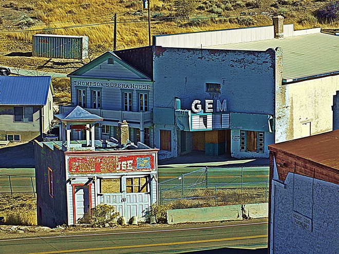
downwards) Following the road into town a short
section leads through an interesting main street.
The gas station sells a few basic frozen burritos
and other groceries at reasonable prices. I'm told
the next grocery store in Panaca is actually more
expensive. Two possibilities lead back to US93.
The profile takes the direct one (staying right at
the fork), then crosses 93 and continues along
another pleasant paved road without traffic to
speak of, to a low point in Lake Valley.
Dayride with this point as highest summit: COMPLETELY PAVED: ( < Hancock Summit | Meloy Summit > ) Pioche s(u) , Nv322 Ursine Rd s(u) , additional out and back : a few miles south of Echo Dam Rd - Delmues Ranch Rd > Delmues Ranch Rd south > Nv319 west >. Panaca > US93 north <> out and back to points in Cathedral Gorge State Park >> Nv321 north > Pioche s(u) > city streets west with sightseeing detours > Nv322 Ursine Rd east > Ursine with detours > paved road following Eagle Valley (Echo Canyon Rd?) south > back to starting point along Delmues Ranch Rd: 61.8miles with 3240ft of climbing in 5:23hrs (garmin etrex30 m3:19.11.7) Notes: contains several roads just paved in recent years, that are not shown on my map - perfect weather and everything else |