| |
| |
FR002 Toiyabe Range s(u)
When crossing Nevada on the
popular US50 bicycling route, The Toiyabe Range
seems like the most formidable obstacle between
Utah and Californina. As usual the paved route
makes it as easy as possible, using a low shoulder
on the north side, Austin Summit.
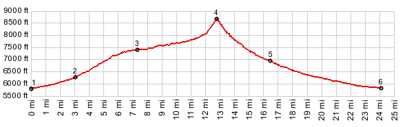
I think this dirt road climb is scenically much
more interesting, and shows the grassy triangular
peaks of the Toiyabe Range from a better side.
According to my notes this forest road is labeled FR002, but google maps labels it NF12
From East. Riding down Nv376 through Big
Smoky Valey, you can see the collection of
structures, that make up Kingston, for dozens of
miles before you actually get there. They sit
above on an alluvial fan, that looks as perfectly
fan shaped as anything you might find in an opera. The profile starts where a paved road leaves
Nv376 to climb to the "gateway to the Toiyabe
Range" as the sign proclaims. But the commerce in
this gateway town is held to manageable levels.
There is a General Store, and another
establishment, that anounces with billboards that
it might be capable of serving food. Both of the
them are closed when I pass by. Luckily I still
have plenty of water in my bottles. Both options of the only paved intersection in
town lead to the start of FR002, following
Kingston Creek through a narrow canyon up into the
mountains. After all that stark dessert, the
rushing stream and soft noises of leaves blowing
in the wind are a welcome change. Gradually the
road comes across steeper sections. Kingston
Campground has no water but charges no money
either. It looks like one would find plenty of
peace and quiet here. The following guard station
houses have also been abandoned. By the time the
road passes a small lake, the surrounding Toiyabe
Mountains have become an overlapping series of
green, grassy cones and triangles. A trailhead to
the Crest Trail, immediately after the lake, looks
like an inviting hike with incredible views. The road just follows the creek further up, until
a sign stating "trailers not approved" hints of
changes to come. Sure enough, a quarter mile later
a road cut appears in view, high up on the grassy
mountain face ahead. The road makes a strong twist
upward. It is enough to make me walk the next
several switchbacks. The top of this unnamed pass
comes up completely unexpectedly, just when I am
starting to really look forward to a good view. On both sides of this pass double track trails
lead steeply higher. The one on the west seems to
go all the way to the ridge line. The other one
tops out on a lower hill. I included some of the
the pictures of a short walk up the west side of
the pass.
From West. (described downwards). The
very top section on this side is deceptively steep
too. No brakes can stop you, so to speak. After
that a fast descent follows Big Creek downward
over several stream crossings. The road continues
to descent past Big Creek campground, well out
into the alluvial fans of Reese River Valley. The
bike still hardly needs extra pedal power to move,
when the Toiyabe Rage has already become a distant
set of green triangles, almost like a cubist
painting. Here the road does eventually reach a
low point and climbs again slightly before
reaching US50 and Austin. Dayride PARTIALLY PAVED / UNPAVED ( < Pete's
Summit | Austin Crest
Trail s(u) > ) |
 Approaches


|
|
advertisement |
|
|
advertisement |