| |
| |
Austin Crest Trail s(u)
Thanks to the effort of one bike
store owner, the town of Austin is a mountain
biking destination. Or maybe it once was this way.
The bike store owner, who once worked on marking
and publicizing these trails has moved on to Ely,
just like the old silver miners that founded the
town have moved on to other productive spots. And
just like the miners have left their rock piles
and ore tailings, the bike store owner has left
the signs pointing the way to a handful of
mountain biking routes, through the maze of forest
roads in this area.
All of these are really great rides, and they are centered around Austin Summit and the campground on Bob Scott's Summit. A ride over the Austin Crest Trail, is definitely not the most ridable of these, but easily the most scenically stunning with prime views onto the Toyabee Range. One more thing about Austin. People live here, but there is no grocery store, just two gas stations competing in who can charge the most for a gallon of gas, and double the price for a gallon of milk. The Austin Toyabe Mountain bike trail guide is available for free at the city hall. This pamphlet also lists "grocery stores", well just one: the General Store in Kingston - god knows how many miles to the south east. However if you want to go antique shopping after or during the bike tour, this town is tailor made. For more pictures see the slide show link on the left.
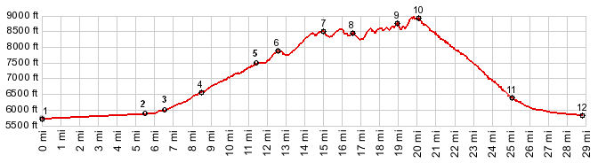
From South. The profile shows the maximum
elevation gain, and starts near the lowest point
in the Reese River Valley below Austin, just to
give an idea about the size of this landscape. On
a loop ride the lowest point would be at point 3,
or a little higher if one follows the edge of the
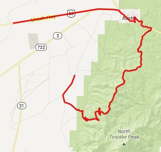
Toiyabe Range a little closer. US50 leads to the top of Austin Summit,
but you can also bypass this stretch of road with
a dirt road to the south of the paved road. From
the top of Austin
Summit, dirt roads leave in both directions.
This one heads south, heading for a transmission
facility, that can be seen while riding to Austin
Summit. After the first steep uphill section,
there is a ghost bicycle trailhed of sorts: a
bikerack overgrown with weeds, an unexpected,
elaborate stone bench, and a map sign post. But
the post is empty, just bare wood. It looks like
once upon a time, bikers were taken up here with
automobiles to start their ride here. - Well -
just riding to this location is a better idea
anyway. The first of many downhills followed by a
slightly steeper uphill leads to the transmission
facility. After the trailhead intersections are
marked with arrows. The Crest Trail follows the
option 5, just like the Austin - Toiyabe Mountain
bike trailguide booklet (available for free in the
Austin City Hall) says. Other things in this
little booklet may be out of date, like for
example there is no more mountain bike shop . But
the majority of these little numeric signs seem to
have survived. Past the first dip the amazing sight of Toiyabe
Peak comes into view. It is not rocky alpine, but
more like a set of green grass faces. Up here
above the dessert the wild flowers are blooming,
the grass is green, the sky blue and the
temperature is perfect under the clear sky. 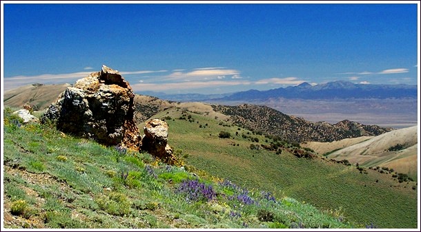 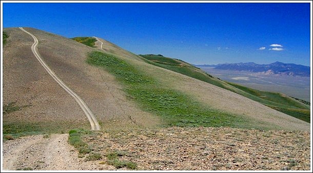 The old ride brochure states for this ride:
"cyclists might find themselves walking in
places". I think cyclists will definitely find
themselves walking in places. And I don't think
that technology will ever come up with anything
that would provide enough tire traction, so that
one could ride up some of these slopes, even if
somebody would develop the leg power. The dips and rises seem to become more severe, or
maybe I am just getting more tired as the ride
progresses. They dips and climbs be seen ahead
over the green ridgeline, like a cut on a
watermelon. Each climb also gets you a little
higher than the preious one. Some of the peaks
have a single track cutoff option around the very
tops. The profile above follows the main trail
over all the intermediate summits, labeling just a
few of them. Finally the track reaches the highest
point. An additional unexpected object comes into
sight: The workings of an old silver mine and its
cliff cuts. This is not an old historic mine, but
a recent operation from the 80s and 90s. From North. (described downwards).
Somehow this ore had to be transported to the
valley. So it doesn't come as a surprise that a
wide, elaborately engineered rock cut with road
leads down Dry Canyon, back into the Reese RIver
Valley. Even if forest maps do not show it, it is
also possible to descent through the mined area to
the east to Big Smokey Valley. To the east there
is also another more jeep trail like possibility
to descend. Dayride PARTIALLY PAVED / UNPAVED ( < FR002
Toiyabe Range s(u) | Basque Summit
> ) |
 Approaches
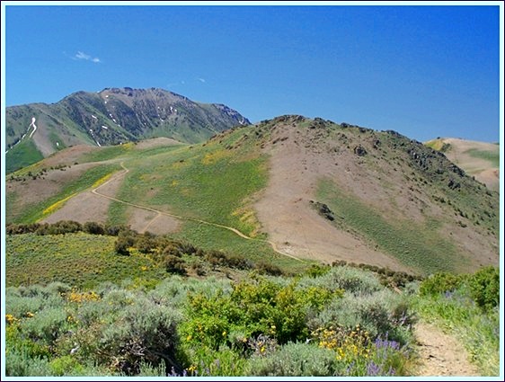
|
|
advertisement |
|
|
advertisement |