| |
|
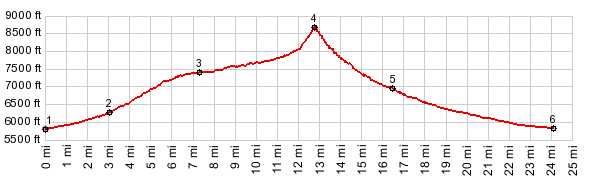
1.(5630ft,mile00.0) START-END EAST: jct Nv376 - Kingston Canyon Rd
2.(6320ft,mile03.1) FR002 Kingston Canyon Rd enters Kingston Canyon
3.(7500ft,mile07.4) road reaches south end of Groves Lake
4.(8580ft,mile12.9) TOP: highest point of FR012
5.(7060ft,mile16.5) jct with North Fork Big Creek on right. Profile stays left
6.(5820ft,mile24.2) START-END WEST: low point at jct: Big Creek Rd - dirt road heading directly west
|