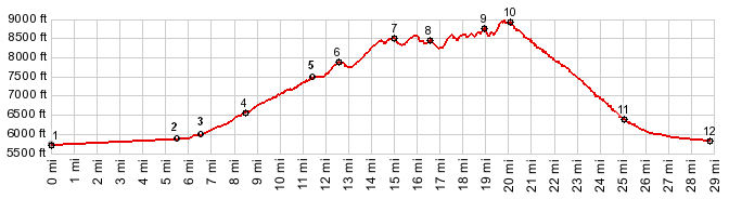
01.(5730ft,mile00.0)START-END WEST ALT:
jct US50 - Old Overland Road
02.(5880ft,mile05.5)jct US50 - Nv722, west of Austin
03.(6030ft,mile06.7)START-END WEST: jct with Big Creek
Rd on left, access to Toiyabe Range summits
04.(6590ft,mile08.6)center of Austin
05.(7484ft,mile11.5)Austin Summit, profile turns right
up towards Austin Crest Trail
06.(7850ft,mile12.6) Austin Crest trailhead near Union
Hill
07.(8480ft,mile15.0) intermediate summit
08.(8430ft,mile16.5)intermediate summit
09.(8720ft,mile19.0)intermediate summit
10.(8850ft,mile20.1)TOP: highest point on Austin Crest
Trail, profile turns right shortly after this
11.(6390ft,mile25.1)profile stays left, heading further
down into valley
12.(5830ft,mile28.9) low point on Big Creek Road at the
jct with dirt road heading directly west