| |
| |
Emigrant Pass
This ride over the old pony
express route, parallel to the western approach to
Austin Summit,
is written up as ride No.6 in the Austin - Toiyabe
Mountain Bike Trail Guide, a free booklet
available at the Austin City Hall. The booklet
describes the ride in the opposite direction as I
do here, which is pretty much all downhill and
therefore "easy". Doing the ride in the direction
described here, takes a little bit of creative
sign interpretation, because the cyclist -
directed signs are designed to be read from the
other direction.
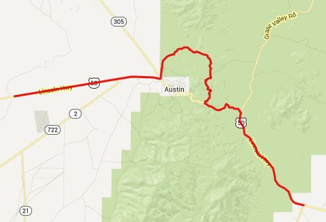
From West. Between the intersection of
Nv305 and US50, just west of Austin, there is an
easily missed paved turnoff onto a forest road.
That is the start of a ride up Emigrant Pass. This
is one area where many of the roads, that exist in
reality, are not shown on google maps. But the
roads do show up on the satellite view. The road
passes a Toiyabe Forest guard station (useful for
getting maps and clarifying directions) and then a
sign tells you that you are on FR184. A rounded mountain appears ahead. But before
getting close enough, that this mountain has any
chance to look imposing, the route turns right
onto FR43222. The turnoff is easily missed, but
signed from the opposite direction. Following the
route in east-west direction, the turn is obvious,
since you want to continue going downhill. This smaller FR43222 makes its way through sage
and open brushy forest to crest at a cow grate.
Here a view opens up onto the bare breadloaf of
the Simpson Park Mountains and the more form rich
flowing peaks of the Monitor Range. But this is not the pass. Another right leads
onto FR43223. Again the turnoff is signed from the
opposite direction. This road is in the process of
being grown over, and gophers or other animals
have dug a few craters into the surface that are
big enough to swallow even a 29 inch mountain bike
wheel. But taking once eyes off the ground, and
checking out the surroundings is very tempting.
The views are steadily improving, and the road is
still climbing, and now facing the Monitor Range.
After two false summits, finally the real one
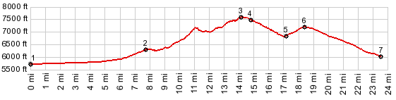
comes into sight. 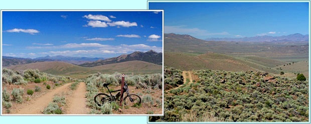 left : view east from summit point at mile 11 right: finally getting closer to the pass and looking north From East. (described downwards). And in
the same view, the end of the trail and the
junction with US50 on Austin Summit
also appears. The profile includes the ride back
down through Austin to the jct with FR184.
Optionally there is also a dirt road into Austin
on the south side of Austin Summit. A Dayride with this ride as intermediate
summit is on page: Austin Crest
Trail s(u)
|
 Approaches
|
|
advertisement |
|
|
advertisement |