| |
| |
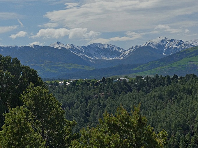
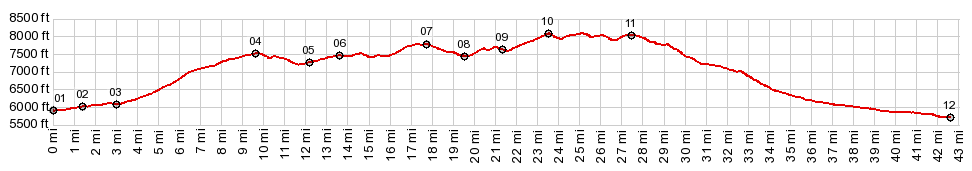
NM76 Trampas - Truchas This is the highest point on
a loop through old hispanic villages,
modern pueblo outposts, deep forests and
three separate Spanish missions a little
older than the US itself, all below the
Truchas Peaks, which make up the final
exclamation point of the Sangre de Cristo
Mountains to the south. The
profile actually goes over three separate
that have a minimum 300ft elevation gain.
I only count one of them as a separate
summit (because there is no way to get
500ft below the high point, even if
doubling back to the other aproach were
possible) The other point can be
approached separately with larger
elevation gains: NM76
Chamisal - Trampas
There are actually two points
that fit that description. The real summit
appears to be the more northerly one.
From
East. (describe downwards). Sweeping
turns lead to the first great view of the
villageTruchas and yet another version of
the Trampas Peaks view. Truchas is situated
on the edge of a mesa. Clearly this location
was chosen for something different than
being easy to reach for people looking for
shopping mall outlet stores on a weekend.
The location above the valley and below the
peaks is a choice location. The villlage
attained a certain amount of fame in the
movie "the milagro bean field wars".
Superficially, judging purely from
appearances while cycling through it, it
seems to not have caused any lasting harm.
Looking around this old village is slightly
off the profiled route, which turns right
before entering Trampas. But it is the most
interesting exploration along the entire
route. The old mission there was built in
1775. Since my first visit the surroundings
have been slightly modified. See pictures in
the slideshow below
On the other hand, the neighborhoods of Espagnola are a fascinating territory to explore on a bicycle, expecially when only used to typical US suburban developments. According to a report on NPR from several years ago, Espagnola was (and probably is) also the main distribution hub for heroin arriving from Mexico. An especially unpredictable traffic area in my experience is the area around the casino. - Another famous attraction, the Chimayo Mission is also not far away from the route before entering Espagnola
Dayrides with this point
as highest summit:
COMPLETELY PAVED: ( < FR222 Petaca s(u) | FR639 Truchas Peaks > ) P3: NM76 Trampas - Truchas s(u) , NM76 Trampas - Chamisal : jct FR667 - FR639 > down FR667 > Truchas > NM76 north > E spanola > Santa Cruz > McCurdy Rd north > NM68 north with small detour > La Junta > NM75 east > Dixon > NM75 Dixon - Rio Lucio high point > Rio Lucio > Rio Pueblo > NM76 south > Chamisal > NM76 Chamisal - Ojo Sarco s(u) > Las Trampas > NM76 Truchas s(u) - Trampas > Truchas > back to starting point at jct FR667 - FR639 : 71.3miles with 4790ft of climbing in 6:12hrs (garmin etrex30 r4:21.6.1) (pics: t21_4_23 - t21_4_38) Notes: contains a small part of umpaved road, used to aproach the loop. A lucky day of great weather, after a day of heavy rain and hail. Fairly heavy traffic in the Rio Grande Gorge on this June1 ( < Wolf Creek Pass | ) > P1: same summit points: somewhere along NM518 towards US Hill Summit > NM518 south > NM76 south > Chamisal > NM76 Chamisal - Ojo Sarco s(u) > Las Trampas > NM76 Truchas - Trampas > Truchas > detour trough Chimayo > Espagnola > :NM 68 north through Rio Grand Gorge > NM75 east > Dixon > NM75 Dixon - Rio Lucio high point > Rio Lucio <> detour around Picures pueblo > back to staring point on US Hill Summit: 92.3miles with 5860ft of climbing, no time measured (cycle computer: m2:96.5.30) (pics t96_1_1101 - t96_2_0103). Notes: solo day ride after DBTC Sawatch > Pagosa Springs > Chama > Alamosa 3 day ride ( < Chosa Pass | Lagunita Saddle > ) P2: same summit points: jct NM68 - NM75 > NM68 through Rio Grande Gorge north > Espanola > Truchas > NM76 Truchas - Trampas s(u) > Las Trampas > Chamisal > NM76 north > Rio Pueblo > Rio Lucio > NM75 - Rio Lucio high point > Dixon > back to starting point 74.8miles with 6630ft of climbing in 6:49hrs (cyclecomputer m3:5.6.15) (pics t05_5_19-23) Notes: with Bob A Dayride with this point as intermediate summit is on page: FR639 Truchas Mountains 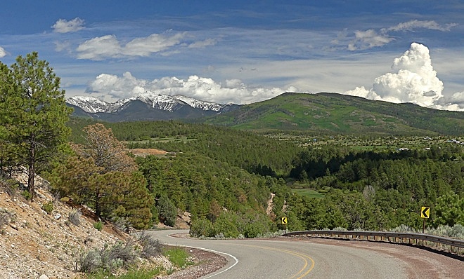 |
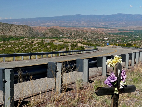 Meanwhile, back
on the profile: Now comes the great decent
into Espanola. Watch the landscape turn into
a dessicated dessert, and Truchas slowly
rise in relative elevation to the observer,
still clinging to the edge of the mesa. At
first the road is wide with a shoulder the
width of an entire lane. Then, as NM76
enters Espanola and its "suburbs", the road
becomes narrower and more heavily
trafficked. The profile stays on NM76 to its
junction with Santa Rosa Rd. Just past that
is the 3rd mission along the route. But this
one lacks the peaceful picturesque
surroundings. If connectiong to points north
and the Rio Grande Gorge, as the dayrides
below do, it may be a good idea to cut
through Espanola further north.
Meanwhile, back
on the profile: Now comes the great decent
into Espanola. Watch the landscape turn into
a dessicated dessert, and Truchas slowly
rise in relative elevation to the observer,
still clinging to the edge of the mesa. At
first the road is wide with a shoulder the
width of an entire lane. Then, as NM76
enters Espanola and its "suburbs", the road
becomes narrower and more heavily
trafficked. The profile stays on NM76 to its
junction with Santa Rosa Rd. Just past that
is the 3rd mission along the route. But this
one lacks the peaceful picturesque
surroundings. If connectiong to points north
and the Rio Grande Gorge, as the dayrides
below do, it may be a good idea to cut
through Espanola further north.|
|
advertisement |
|
|
advertisement |