| |
| |
NM4 Valle Calderas s(u) The summit area of this
climb is, as the name says, is a large
caldera, ie. a big remnant of a collection
of craters, left after a period of
volcanic explosions. Compared with the
next big caldera to the north, the Molas
Caldera in Colorado, this one looks very
different. It gives the appearance of a
pleasant high grassy bowl, surrounded by
countless high hills, shaped like upside
down soup bowls - a few cups amongst them.
There are no rugged peaks here, like in
the Molas Caldera. This can be a good
place to escape summer heat in New Mexico.
From
West. The profile starts roughly,
where NM4 enters Jemez Canyon. Jemez Springs
is located a few miles up, in this wide
canyon, now delimited with vertical walls on
both sides. Several cafes and a community
park with a water spigot hide in its shadowy
recesses. When rolling down into this
village from the other side, the site of the
old Jemez Pueblo can be missed. But climbing
towards the east remnants of old natural
stone walls next to the road make one take
notice. If that isn't enough there is a
modern catholic church doubling as a
monastery on the other side of the road.
The road continues to roll
along, climbing little by little, until it
reaches what seems the edge of what first
looks like a typical western mountain park,
ie is an expansive grassy valley, surrounded
by mountains, even if they are not quite as
high here. This is the caldera, and the
"mountains" or "hills" bounding this park
are the most recent extrusions of volcanic
rocks left long after the original
explosions. But there really is no
descending into the caldera. Instead you
just keep traversing up a ridge with ever
improving views onto the huge lawn below. 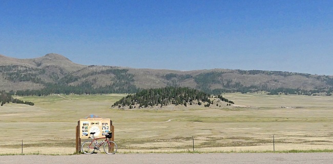
At the point where the route
enters the dissected plateau and starts
climbing, there is a choice to make. Staying
on NM4 is a longer and quieter ride, leading
by the entrance to Bandelier National
Monument. NM501, shown on the profile,
climbs directly into Los Alamos - more
interesting views of the landscape and the
fairly spectacular setting of the most
modern New Mexco settlement. But it also has
a lot more traffic, and no shoulder in some
of the steeper parts. The route leads
through Los Alomos and its numerous
off-limit entrances. At least there is a
grocery store and a park with museum one
could visit if so inclined. The road keeps
climbing by more numbered "tech area
entrances" leading to boxed in mystery
technology and research. On the outskirts the two
approaches from Los Alamos and from
Bandelier NM unite again. The junction is a
popular shoulder summit for Los Alomos
cyclists, combining these two roads in a
loop. I saw the most cyclists in all of New
Mexico here on this trip so far - about 20
of them, dispersed into small groups or
riding solo. They are also the only cyclists
I have seen in New Mexico since entering the
state more than a month ago, not counting
two children within 500ft of their homes.
Every one of them rode the loop in question
in the opposite direction (ie down NM501, up
NM4) From this upper junction of
NM4 and NM501 the road climbs up the bare
mesa with a single, radical switchback and
two steep ramps. Bingo - we're on the
slanted edge of another mesa shelf. The road
gets a chance to straighten out, and crosses
into Santa Fe National Forest land. There is
an unofficial camping area in the woods here
- actually the last chance next to NM4 for
many miles. Over the next miles the road
changes several times between National
Forest land, National Monument and National
Reserve land status, and camping is not
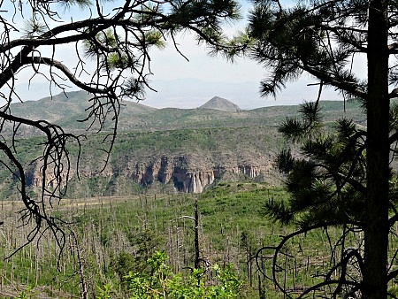
allowed in the last two. The climb from here along the
plateau often shows off far views with the
Sandia Mountains, a vague shape in the haze,
in the foreground a burned matchstick forest
leading to the edge of a canyon. Soon the road enters high rolling forest At what feels like the top two trails take off from the the road, one to a high cerro above the Valle Calderas, the other one down to a canyon overlook. Both are good for a short hike. But the actual highest point on the road was an inconspicuous roller hill before that.
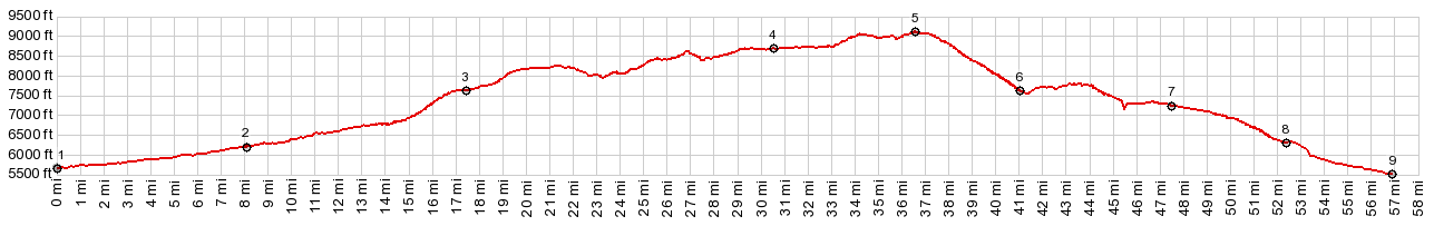
Dayride with this point
as highest summit:
( < US Hill Summit | NM126 Fenton Lake - jct FR20 > ) NM4 Valle Calderas s(u) x2 : camping spot next to NM4 at 8160ft, a couple of miles west of jct NM4 - NM501 <> out and back NM4 west <> Valle Calderas s(u) << turn around point in Jemez Springs community park: 64.6miles with 5420ft of climbing in 6:08hrs (garmin etrex30 r4:21.6.10). Notes: 94 degrees in Albaquerque, reasonable morning and hot afternoon at 9000ft. Lower part of the profile was recorded during a second ride, with jct NM4 - NM501(sh) as two way summit, and additional approach from above. |
 The climbing is
fairly continuous. After a major workout
(major - especially it it is hot, like my
last time), the road passes a viewpoint on
the canyon just climbed. If you stand on one
of the benches and jump up and down high
enough you might even be able to see the
road and canyon below through the trees.
The climbing is
fairly continuous. After a major workout
(major - especially it it is hot, like my
last time), the road passes a viewpoint on
the canyon just climbed. If you stand on one
of the benches and jump up and down high
enough you might even be able to see the
road and canyon below through the trees.|
|
advertisement |
|
|
advertisement |