| |
| |
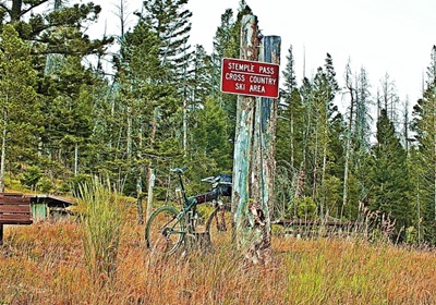
Stemple Pass
From
West. (described downwards) Fast and
smooth as the other side - surrounded by
forest. The first view of the actual far
landscape is at the bottom, entering
Lincoln. 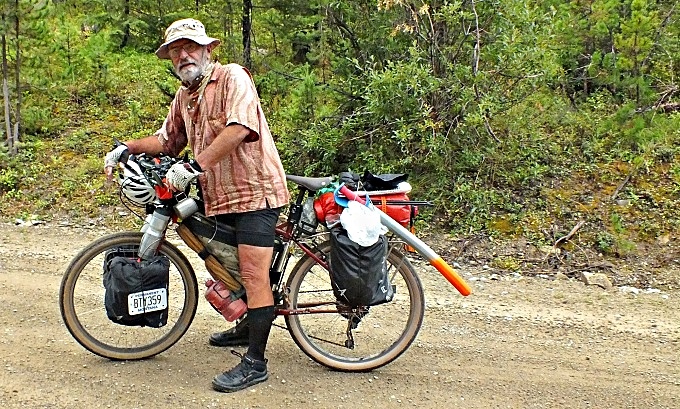 Dayride with this point as highest summit PARTIALLY PAVED / UNPAVED ( < MacDonald Pass | Marsh Creek Rd s(u) > ) Stemple Pass , Flesher Pass , additional out and back : several miles up Stemple Pass Rd from jct Mt279 - Stemple Pass Rd > up Stemple Pass Rd <> several miles of out and backs on roads crossing the pass at the summit >> down west side of Stemple Pass Rd > Lincoln > US200 east > Mt279 sourh > Flesher Pass > back to starting point on east side of Stemple Pass Rd: 59.3miles with 3900ft of climbing in 5:03hrs (garmin etrex30: m3:20.8.19) Notes: a pleasantly cool morning after it stopped raining, on this - another day of forecast heatwave in the 90s in YPR listening area. Heat was back in the afternoon. On west side of Stemple Pass I met GDMBR cyclist George. We took each others pictures. He has starred in many, including at one time, almost weekly pictures at the Adventure Cycling web site, with whose founders is is friends. He tours with dynamo, portable charger, and apnia sleeping aid machine. Hope i will be able to ride like this when i am in my 70s. All the best to you. Note the bear repellent in form of a daggar like instrument in the back. |
 The
Continental Divide is sometimes honored
with great descriptive terms, such as "the
Backbone of the Continent". The
description does not apply well to the CD
north west of Helena. These gentle wooded
hills, interspersed with grassy triangular
forms would barely be foothills in some
other parts of the Continental Divde. But
they are a gently, picturesque landscape,
perfect for many tracks, trails, and roads
to run across the divide. The GDMBR guide
book calls this area "overroaded" - first
time I ever saw this word. In any case, it
doesn't seem like many people take
advantage of this "overroadedness". And
that's what makes these roads special.
Most of the paved roads in this area are
"undershouldered" and
"overrumblestripped". So an abundance of
dirt roads to choose from seems only
right. Stemple Pass is one of these
unpaved roads with an excellent, smooth
surface, perfect for any gravel bike, even
a road bike would be just fine. The
western side is part of the alternate
GDMBR route.
The
Continental Divide is sometimes honored
with great descriptive terms, such as "the
Backbone of the Continent". The
description does not apply well to the CD
north west of Helena. These gentle wooded
hills, interspersed with grassy triangular
forms would barely be foothills in some
other parts of the Continental Divde. But
they are a gently, picturesque landscape,
perfect for many tracks, trails, and roads
to run across the divide. The GDMBR guide
book calls this area "overroaded" - first
time I ever saw this word. In any case, it
doesn't seem like many people take
advantage of this "overroadedness". And
that's what makes these roads special.
Most of the paved roads in this area are
"undershouldered" and
"overrumblestripped". So an abundance of
dirt roads to choose from seems only
right. Stemple Pass is one of these
unpaved roads with an excellent, smooth
surface, perfect for any gravel bike, even
a road bike would be just fine. The
western side is part of the alternate
GDMBR route.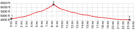
|
|
advertisement |
|
|
advertisement |