| |
| |
FR485 Marsh Creek Rd s(u) The Continental Divide
between Helena and Lincoln is gentle
enough to contain a multitude of pass
roads, and also this unnamed summit,
located on the GDMBR route. It is actually
higher than any of the named passes, and
an additional out and back to a lookout
tower provides an even better impression
of the scenery along this part of the
divide.
From
South. The downhill is common with
the CD trail for a while. Where the two
split the temptation to follow the track of
the CD trail is strong. But the GDMBR heads
downhill along a fast and furious decent on
the same old Marsh Creek Rd. The road
transverses a large zone of pine beetle
devastation and then stays at the bottom of
a wooded valley. Before reaching the jct
with Prickly Pear Rd, the GDBMR cyclist is
greeted by old bicycles doubling as artistic
expressions by the roadside, and perhaps
calls to take a rest on an inviting large
green meadow. This is the GDBMR rest stop
area of Barbara and Tom. More in the Notes
below and on the next
page:
Sidetrip to Granite Butte
Lookout This detour is only about a
mile or so long, and it does buy a lot in
the elevation department. The last part goes
steeply up an open meadow to a lookout
tower, flanked by a grove of dead trees -
the only good dead tree scenery around for
many a mile
Dayride with this point
as highest summit:
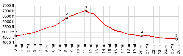
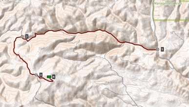
PARTIALLY PAVED / UNPAVED ( < Stemple Pass | Ottawa Gulch Rd s(u) > ) FR485 Marsh Creek Rd s(u) : several miles up Stemple Pass Rd from jct CR279 - Stemple Pass Rd > up Stemple Pass Rd > Stemple Pass(shp) > FR 485 south > FR485 Marsh Creek Rd s(u) <> out and back to Granite Butte lookout > FR485 south > down Little Prickly Pear Rd > CR279 north > back to starting point on Stemple Pass Rd: 36.3miles with 3340ft of climbing in 4:17hrs (garmin etrex30 m3:20.820), Notes: the orignal plan was to keep going over another summit direction Marysville. But when I started talking to Barbara and John and the GDMBR bikers being entertained there, I cut short these plans, substituting to visit here tonight (picture below) 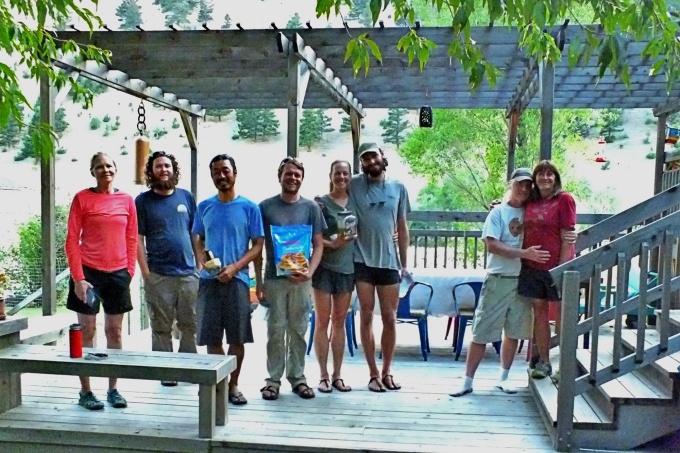 |
 The
GDMBR turns right at the next jct to climb
up to
The
GDMBR turns right at the next jct to climb
up to 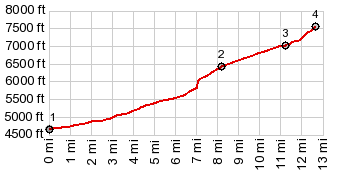
|
|
advertisement |
|
|
advertisement |