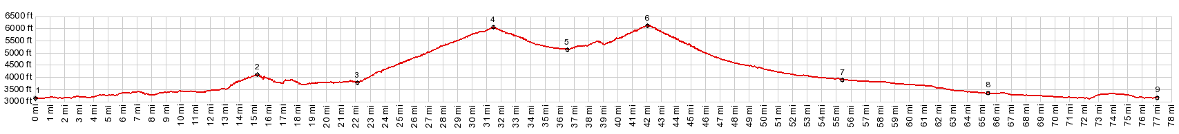
This is the highest point on Id21
between Boise and Lowman - also just a little
higher than the nearby Beaver Creek Summit. This
is mostly a pleasant forest ride, although there
is more variable scenery over on the Beaver
Creek Summit part of the profile
The bicyclist, looking at the map and then
expecting a lazy downhill from Beaver Creek Summit
to Idaho City is disappointed. The road starts
climbing again. But it's short and not steep. The
top has a single sign facing in one direction, a
large parking lot with an intersection with
various forest roads, including one to Pilot Peak,
that looks interesting. The view contains forest,
some far, but mostly very near.
From South. (described
downwards) The fast variable descend still
provides plenty of opportunity to get some more
padaling workout in. Thsere are actually
surprisingly numerous fairly tight switchbacks on
this side (as well as on the north side). But
often you don't realize it because dense forest
obstructs the view of the road. Ihaho City is a historic mining town, that has
been fixed up touristically, without obliterating
its charm completely. There are two expensive
grocery stores and a nice library. Below here the
profile is just a road in the forest, following a
small stream until the road crosses the Canyon of
the Boise River and starts a short climb to
Highland Valley Summit. 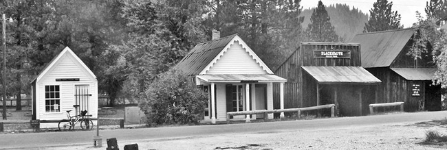 Idaho City Dayride with this point as highest summit: PARTIALLY PAVED / UNPAVED ( < FR307
Centerville Rd | FR500
Oakley - Rogerson Rd(sh) > ) Mores Creek Summit , Beaver
Creek Summit , Grimes Pass
, FR307
Centerville Rd s(u) : top of FR307
Placerville Rd s(u) > GR307 west > New
Centerville > Grimes Pass Rd north > Grimes
Pass > Garden City > paved road along South
Fork of Payette River east > Lowman > Id21
south > Beaver Creek Summit > Mores Creek
Summit > Idaho City > FR307 Placerville Rd
west back to starting point: 84.6miles with 7310ft
of climbing in 7:30hrs (garmin etrex30 m5:17.9.16( |
|
|
advertisement |
|
|
advertisement |