| |
| |
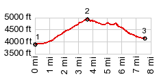
FR307 Centerville Rd s(u)
This busy dirt road summit connects
paved roads in Idaho City with Placerville and New
Centerville. It makes a number of loop rides over
higher paved and unpaved summits possible.
From West. (described
downwards) - quick, slightly sandy descend to New
Centerville in the woods. From there on the road
is paved,
( < Adape Summit | Mores Creek Summit > ) FR307 Centerville Rd s(u) : about 2 miles
up FR364 Grimes Creek Rd > Grimes Creek Rd
north <> out and back at a confusing
intersection > New Centerville with a
sightseeing detour > FR307 Centerville s(u)
> Idaho Springs <> Id21 south > Grimes
Creek Rd north back to starting point: 40.0miles
with 2110ft of climbing in 3:54 hrs (garmin
etrex30: 17.9.15)
A Dayride with this point as intermediate
summit is on page: Mores Creek
Summit
|
 Dayride with this
point as highest summit:
Dayride with this
point as highest summit:|
|
advertisement |
|
|
advertisement |