| |
| |
Loristica campground s(u) This is a dead end road to a
closed campground and trailhead, high in
the Lost River Range, one of the major
fault block ranges in dry Central Idaho -
the best part of Idaho, as far as I am
concerned. The north side has only a small
out-and-back descend, yet big enough for
me to call it a two way summit here. -
great views and fast biking conditions,
suitable for a gravel bike.
From
South. (described downwards).
Loristica campground is apparently for
groups only, and when I was there the gates
were locked. A little further down is the
trailhead for Long Lost Wet Creek Trail. It
climbs towards the peaks to the east, but is
so indistinct, that it is better to follow
your own route. The road itself deteriorates
a little and descends to the creek, where it
appears to end. Judging by the size of the
barriers this is the site of a major land
ownership battle. The trail continues
on public land for a little while longer.
From the last fences and barriers you can
make out a road, that connects back to the
Pass Creek Summit Road. But for all
practical purposes the route ends here.
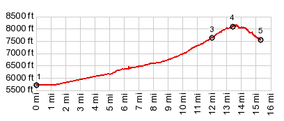
Dayride with this point as highest summit 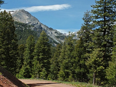 ( < Craters
of the Moon NM s(u) | Corral
Creek Summit > ) ( < Craters
of the Moon NM s(u) | Corral
Creek Summit > )Loristicia campground s(u) x2 , Pass Creek Summit : a short distance up Pass Creek Summit Rd <> out and back down the road to National Forest boundary > up Pass Creek Summit Rd > Pass Creek Summit(shp) <> out and back up Loristicia campground rd > Loristica campground s(u) x2 << turnaround point at end of road >> down east side of Pass Creek Summit << turnaround point at jct with Dry Creek Rd to Patterson > back over Pass Creek Summit west > back to starting point : 43.0miles with 4260ft of climbing in 4:51hrs (garmin etrex30 m3:20.6.11, t20_06) |
|
|
advertisement |
|
|
advertisement |