| |
| |
Craters of the Moon NM s(u) This is a smallest of the
small summits. It just barely fits inside
the cutoff criterium, I have set for these
pages, of having a minimum of 300ft
(~100m) elevation gain on the approaches,
before they (possibly) meet up again. For
somebody visiting this national monument,
it probably comes as a surprise that there
is any climbing at all involved to cycle
to it.
It just goes to show, that thinking of the world in terms of summit points is not necessarily an exercise in boasting about finishing big climbs. It is just a way of thinking about the world, about categorizing it, and ordering it, about putting things in neatly labeled drawers. Some of us cannot escape this desire, while it drives others crazy.
But by the time the turnoff to
Craters of the Moon is reached, the vantage
point onto the Lost River Range behind Arco
has changed quite a bit, and so has the view
onto the grassy slopes of the Pioneer
Mountains. The park road leads past a
veritable administration city and the
campground suburbs into the black rock
landscape. The summit point happens during a
small one way loop. Here also starts
an ever so short walking path to the top of
a cinder cone, where many of the pictures on
this page are taken. By the way, staying on
US20/36/93 the road continues over a
separate defined summit point at about
6000ft. This area constitutes an outlier of
the Pioneer Mountains, as they end into the
Snake River Plain.
From
West. (described downwards). A short
but very steep stretch leads to a junction,
with an out and back park road, going to
tree molds left in the lava. This road does
not lead any lower, but it does constitute a
few more miles of unique scenery. As
mentioned the low point on the one way loop
is just barely 300ft below the summit, where
the profile joins the other approach.
Dayride with this point
as highest summit:
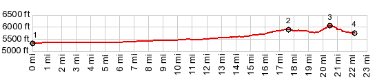
COMPLETELY PAVED ( < Arco Pass | Loristica Campground s(u) > ) Craters of the Moon National Monument(sh): Outskirts of Arco > US23 west > Craters of the Moon NM road south <> out and back to Devil's Orchard area >> Craters of the Moon NM(sh) <> out and back to treemolds trailhead area >> Craters of the Moon loop road north > jct with US23 <> out and back on US23 west to turnaround point a short distance beyond the summit >> US23 east back to starting point in Arco: 52.0miles with 1760ft of climbing in 4:14hrs (garmin etrex30 r4:20.6.10, t20_06) Notes: warm but still comfortable 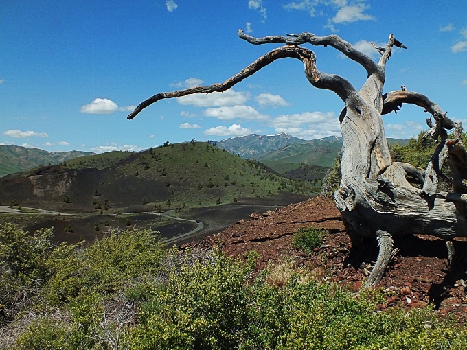 A Day on a Tour with this point as highest summit point COMPLETELY PAVED Actually it took two days to approach this point and ride over it, in order to take advantage of staying at the NM campground for a night. The occasion was my first long bicycle tour, a ride from New York to California in 1973, starting after finishing the thing called high school. 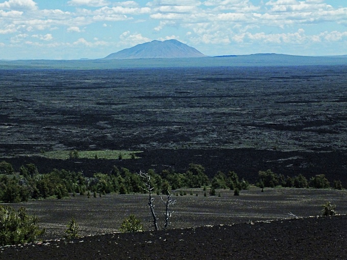 |
|
|
advertisement |
|
|
advertisement |