| |
| |
FR538 Oakley - Rogerson Rd
s(u)
This long, smoothly surfaced dirt
road crosses a high plateau between the Albion
Mountains and the Great Falls area. Even though
the area is very remote, it has a virtual maze of
good bicycle friendly, unpaved roads. This is the
highest point on that road, and given the right
light conditions this can be a very scenic
experience. The profile does not follow the
Oakley Rogerson Rd all the way into Rogerson, but
takes a more direct route to this summit via the
paved Rock Creek Rd.
The cap rocks on this plateau are multiple lava
layers. But this is much more apparent on the west
side because of all the lava capped cliffs - not
so much over here on the east. But there is another interesting series of views
on this side. Directly to the east a chain of
gentle mountains rise to between 8 and 9 thousand
ft: the Albion Mountains. The profile follows
Bostetter Rd and climbs the grassy plateau on a
smooth dirt road, giving a constant, unobstructed
view across the rolling sage plain. FR500 / Bostetter Rd levels out onto the rolling
plateau at about 7200ft. But the snow covered
mountains still seem to form a ring around the
sage hills. The ridge that contains the summit
appears like a set of regular roofs from here, but
these roofs are made of grass and forest. 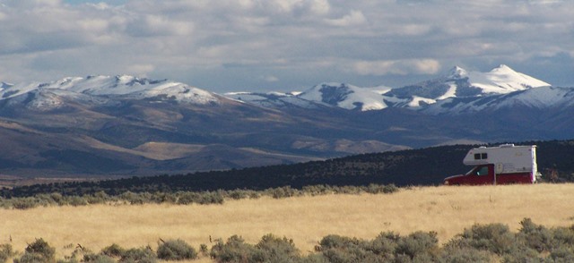 Before getting there the route crosses a shoulder
summit on FR500. It makes the highest point if one
approach goes down Trapper Creek Rd. But the
option shown here stays right and climbs further
on FR500. Nearing the top there are several short
stretches through deep forest, where the snow
lingers much longer. The top can be a fairly
spectacular area, in a desolate kind of way, if
the light cooperates. On this high sage meadow the
view shed changes away from the Albion Range
to other high ranges to the west.
From West. (also
described upwards) Rather than
coming up from Rogerson, the profile takes a more
direct option to this point, using the paved Rock
Creek Rd, which very roughly bisects the Oakley -
Rogerson Rd. This remote and picturesque paved
canyon ride follows along below a whole cast of
lava cliffs, up to a small, rustic ski area: Magic
Mountain. The pavement ends a few miles later and
FR538 leads through a whole maze of forest road on
this gently rolling plateau. This plateau contains
countless shoulder summit possibilities, most of
them obscurely located on grassy plains or forest. FR538 changes width, crosses a few small ravines,
and then contours around a grassy mountain with a
great unobstructed view onto a gentle
mountainscape. After a signed turnoff to Pyramid
Mountain, a last stretch through the forest leads
to the summit meadow
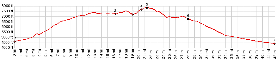
Dayride with this point as highest summit: COMPLETELY UNPAVED: ( < Pike Mtn s(u) | Salt Wells Rd s(u) > ) FR538 Oakley - Rogerson Rd s(u) x2 , FR538 via Trapper Lake Rd(sh) , FR500 via TR10 s(u) x2 : FR500 Bostetter Rd about 1.5 miles before entering Sawtooth NF > FR500 west > FR538 via TR10 s(u) > FR00 west > FR538 - FR533 Trapper Lake Rd(sh) > down FR538 << turnaround point ~900ft below last summit >> FR538 - FR533 Trapper Lake Rd(shp) > FR538 west > FR538 Oakley - Rogerson Rd s(u) > FR538 west << turnaround point ~330ft below summit >> FR538 east > FR538 Oakley - Rogerson Rd s(u) > FR500 east > FR500 via TR10 s(u) > FR500 east back to starting point: 47.1miles with 5400ft of climbing in 5:40hrs (garmin etrex30 r5:17.9.24) Notes: finally a perfectly cold September day with fresh snow on perfectly lit mountains. 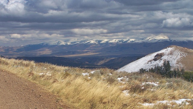 the summit |
|
|
advertisement |
|
|
advertisement |