| |
| |
Pike Mountain s(u)
The road up Rock Creek is probably
the nicest road ride in the mountains around Twin
Falls. But it is an out and back ride. But - using
the plethora of unpaved roads and trails in this
area, opens up virtually unlimited loop ride
possibilities. Every intersection along this route
is meticulously signed with a road number, which
can be found on the Sawtooth National Forest map,
the free version. Without these signs and the map,
getting lost would seem like a certainty. I imagine the scenic interest of
this peak ride depends completely on the weather.
I was lucky on this one. I happened to be here,
just the day after the first light snow of the
year, which transformed the landscape into a new
variation of itself.
A short steep climb leads through a short forest
stretch to a gentle grassy cone shape. About 120ft
below the summit of the peak a trail takes off
towards the right. This is the highest point on
the profile. But the top of Pike Mtn has better
views and most of the included pictures were taken
there.
From South. (described downwards) The ATV
trail has barely any rocks and is a fast MTB ride.
A short forest stretch leads to a dip at the jct
with TR241. From here a short climb back up the
grassy waves in the landscape is the only rocky
stretch on the trail,and it is more easily walked. TR245, then FR523 quickly lead back down to the
Rock Creek Rd on smooth hard dirt, without rocks
but plently of turns. This turnoff on Rock Creek
Rd is not signed.
 Dayride
with this point as highest summit: Dayride
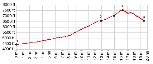
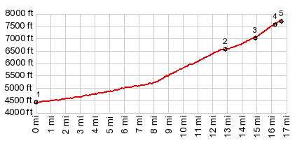
with this point as highest summit:PARTIALLY PAVED / UNPAVED ( < FR500 Oakley - Rogerson Rd(sh) | FR538 Oakley - Rogerson SRd s(u) > ) Pike Mtn s(u) , additional out and back : Rock Creek Canyon Rd, just north of NF boundary > Rock Creek Canyon Rd south > end of pavement <> out and back on Oakley - Rogerson Rd with turnaround point a short distance past the jct with FR671 near Monument Peak >> up FR507 <> out and back to top of Pike Mtn >> TR245 north > FR523 west > back down Rock Creek Rd to starting point: 40.1miles with 4690ft of climbing in 4:57hrs (garmin etrex30 m5:17.9.22). Notes: from heat to smoke to snow this year. This was not the planned route. But continuing on Oakley - Rogerson Rd there was too much snow.  |

|
|
advertisement |
|
|
advertisement |