| |
| |
FR28 Williams Lake Rd s(u) This short climb is just a
little longer than it may seem, while
first looking at it on the map, The reason
are the thousands of degrees of curvature,
negotiated by the approaches. The summit
is not so far away from the canyon of the
Salmon (measuring air distance). Some good
views of a side canyon and the Beaverhead
Range are possible.
Before reaching Williams Lake,
the profile takes a signed right onto FR28,
also the direction of the BLM Lake Williams
Campground and lake access. Crossing an
intermediate high point along the lake, the
road then decents to the creek, feeding the
lake. From here to the summit does
not look like much on the map. But this road
traces back into every nook and cranny of
the now forested slopescape. Most of the way
is on very smooth hard packed surface.
Approaching the top it gets a little
rockier. At the top, a steep two minute
out-and-back walk leads onto a bare knoll
with a nice view in most directions. Many of
the pictures are taken from there.
From
North. (described downwards) But the
nicest views, in my opinion, are on the
upper decent on this side. Rocks turned on
edge, about to be traversed on the way down
are in the foreground: the canyon of
Williams Creek. Behind that: snow covered
peaks of the Beaverhead Range along the
boundary line with Montana. Again the top section of the
road is somewhat rocky, giving way quickly
to a fast comfortable roll down the 1000s of
degrees of curvature. When the road meets Williams
Creek road, the rest of the decent is on a
fast well maintained hard medalled road. The
approach meets the southern approach some
distance above Shoop bridge.
Dayride with this point
as highest summit:
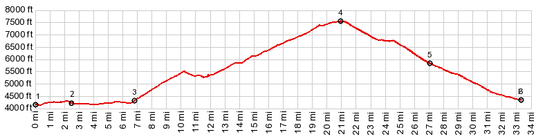
PARTIALLY PAVED / UPAVED ( < Morgan Summit | Williams Creek Summit > ) FR28 Williams Lake Rd s(u) , additional out and back: on FR28, a short distance above Williams Lake > up FR28 > FR28 Williams Lake Rd s(u) > down Williams Creek Rd << turnaround at Shoop bridge, jct with US93 > up Williams Creek Rd > up Williams Lake Rd > up FR28 > back to starting point on FR28: 36.4miles with 4250ft of climbing in 4:08hrs (garmin etrex30: m3:20.6.25) |
|
|
advertisement |
|
|
advertisement |