| |
| |
Danish Pass This pass is a very ridable
great workout in the hills of the Bear
River Range, a good distance east of its
picturesque crest, even if there is not
that much interesting scenery along the
way.
There really are no further
views. From the top you can quickly walk up
a bare knoll, but it does not deliver any
views across the ridge to the east.
From
South. The high shallow valley on
this side is called Egan Basin. The surface
is a little slower than on the Franklin
Basin side. A very well signed intersection
of a total of 4 roads gives the opportunity
to ride to a airplane wreck, climb over
FR411 to Bear Lake , or continue straight
back to US89 along Logan Canyon. 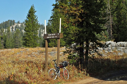
Dayride with this point
as highest summit:
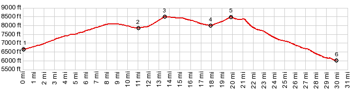
PARTIALLY PAVED / UNPAVED ( < FR406 Franklin Basin Rd(sh) | Wild Horse Loop s(u) > ) Danish Pass , FR411 Egan Basin , Bear Lake Summit : near jct FR406 Franklin Basin Rd - US89 Logan Canyon > up FR406 > FR406 Franklin Basin Rd(shp) > FR415 west > Danish Pass > down FR411 Green Canyon Rd > St Charles > US89 south > Fish Haven > Garden City > US89 west > Bear Lake Summit > back to starting point near jct FR406 - US89: 57.8miles with 4780ft of climbing in 6:07hrs (garmin etrex30 m3:20.9.20) Notes: after the season of heat and smoke comes the season of cool temperatures and smoke |
|
|
advertisement |
|
|
advertisement |