| |
| |
Wild Horse Loop s(u) Looking at this from an
outsider's point of view ...
Travelling through Wyoming on I80, the
section through Green River (and also Rock
Springs) stands out in most people's
memories. The road carves through creme
colored cliffs and buttes with a few
tunnels, and the town slightly below is
orgainzed around the Green River. This is a scenic loop road,
that climbs these cliffs north Green River
and Rock Springs - easily the most scenic
ride in this area. Still the cars I met up
here can be counted with two hands, and
the number of cyclists without the use of
any hands. Large sweeping views of the
dessert below are the main attraction. On
the wildlife side - enormous piles of
horse manure on to the road are also a
potential point of interest.
While I80 tours the buttes and
towers around this dessert town from an 4
lane perspective, this option will offer a
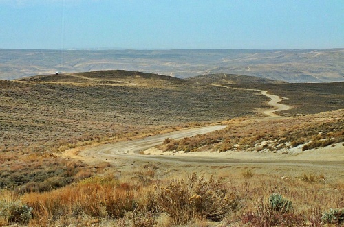
perspective from above. The wide, hard
medalled dirt road starts out in a more
restricted way, followiwng a bare, desolate
canyon. But it does not take long for the
road to reach the sweeping top. The road
touches the edge of the rolling plateau
several times, and there are innumerable
opportunities to explore the rim further. In
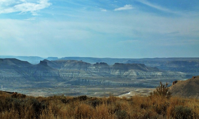
the valley below, Union Pacific trains,
often several in a single panorama, and each
one a mile or longer, take 10 minutes to
traverse the entire field of view, speckled
with rocky towers, white banded rock
formations looking like curtains, and a
uniform carpet of square street pattern
below. Without a map it is virtually
impossible to tell where the highest point
is. Even with a map, you could debate it. I
think it is the knoll immediately after the
unsigned turnoff onto the Gookin White Mtn
Rd, another approach up from Rock Springs. A
point that is only 10 to 20ft lower is
traversed immediately before reaching the
turnoff. Up to the turnoff the road has been
intermediately smooth hard medalled.. After
this the gravel becomes a little coarser.
But it is still easily ridable and free of
washboard.
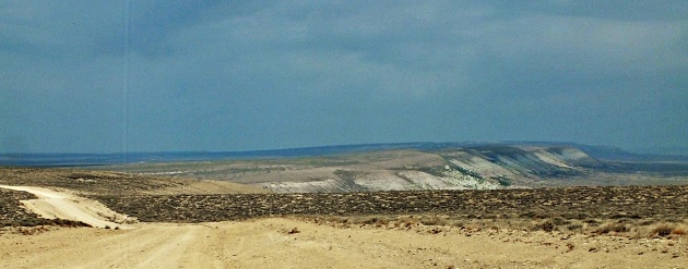
Meanwhile the precipice next
to the road has slowly given way to a vast
sweeping view of the Green River Basin. The
Wind River Range is supposed to form the
ultimate snow covered background, but this
year it has been replaced by a smoky
curtain. The final decent down into the
valley is much more gentle than expected - a
non event so to speak. This wedge shaped
landform seemlessly integrates into the
basin. It is only necessary to travel on
US191 for a very short distance. Then the
excellent traffic free (paved) Yellowstone
Road leads back along the bottom of the
cliff that has just been traversed on the
top. In order to close the loop in Green
River itself, a short section on I80 is
necessary (unless you make a major detour,
which I have not explored).
Dayride with this point
as highest summit:
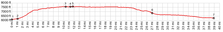
PARTIALLY PAVED / UNPAVED ( < Danish Pass | White Mountain Road via Rock Springs(sh) > ) Wild Horse Loop s(u) : several miles up Wild Horse Canyon > up Wild Horse Canyon > White Mountain Rd north east > Wild Horse Loop s(u) > 14 mile road east > Yellowstone Rd south > Rock Springs with detour > I80 service road west > I80 west > Green River > back up Wild Horse Canyon to starting point: 56.6miles with 2510ft of climbing in 4:48hrs (garmin etrex30 m3:20.9.22)
|

|
|
advertisement |
|
|
advertisement |