| |
| |
One of the most fascinating
areas in Idaho for me, is the transition
from the semi arid Snake River Plain to one
of the great fault block ranges in the US,
the Lost River Range. This pass is the
southern most crossing in this range.
The road is shown on many
maps, that neglect other roads of the same
caliber. But stretches of the Arco Pass Rd
definitely qualify as a jeep road. Still -
on a mountain or gravel bike you can make
good time. In spite of the relatively small
approaches on both sides, there are
phenomenal views of all these dessert ranges
have to offer (given the right light
conditions).
The initial miles of the road
head for a flank of King Mountain (10610ft).
From this side it looks like the crumbled
pages of a set of books, that has been
through a cycle in the washing machine. To
structural geologists it looks like an
irresistible puzzle. Signs at the next
two intersections make sure you stay
on the right path, instead of going to
Woodland Canyon or Beaverland
Pass. At the jct with the latter a
short rocky stretch provides the first
opportunity to stretch out the legs with a
short walk, should you desire to do so. But
all the rocky stretches are very short on
this ride. It all depends on the underlying
rock formation, and much of the road is very
smooth and very bikable. The next sign pointing to Arco
Pass and Hurst Canyon is very confusing. It
points up a little used spur. But all is not
lost, this road ends soon, and the more
heavily used option is now obviously the
right way, no matter what the sign says. A
few more wide stretched curves in the
sagebrush, and the little road seems to
crest below King Mountain, which has a more
alpine look from this side than from the
bottom. In truth this crest turns out to be
a wide sage saddle. The highest point comes
a little later. On the other side the Lemhi
Range starts to make a first impressive
appearance. 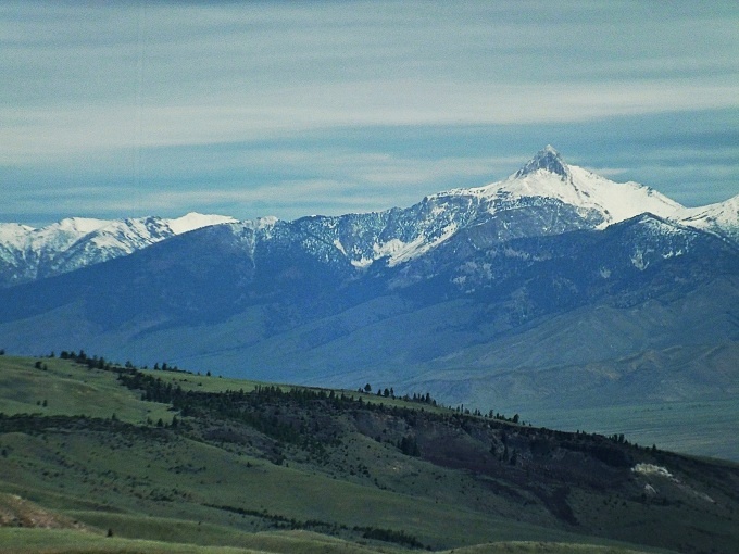
From
East. (described downwards) It is
only 2200 ft down to the lowest point on the
valley floor. But given the right light
conditions, it seems you can see forever.
Along the way, Hurst Canyon turns out to be
a few low lips of rock, that line a
channel in the sage covered alluvial fan.
Later, the road makes a few detours to head
for the small town of Howe. The detours
seems to follow in straight lines some sort
of land ownership pattern. But with the
light and weather that I had, you could
justify every mile as a scenic detour on the
alluvial fan. Howe itself has no businesses
of any sort. But it does have a park for
bring-your-own lunch.
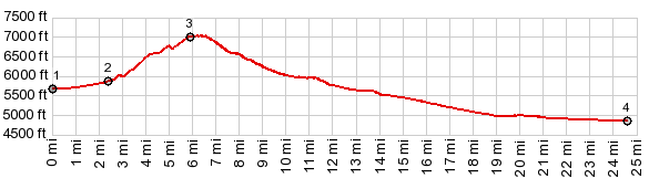
Dayride with this point as highest summit: PARTIALLY PAVED / UNPAVED ( < Beaverland Pass | Craters of the Moon NM s(u) > ) Arco Pass: Woodland Canyon Rd , a couple of miles up from jct Woodland Cny Rd - Arco Pass Rd > down Woodland Canyon Rd > up Arco Pass Rd> Arco Pass > down Hurst Canyon > 3720N Rd east > Little Lost River Hiway south > Howe > Id33 south > US20 west > 2350N Rd east > 2850W Rd north > Arco Pass Rd north > back to starting point on Woodland Canyon Rd : 56.5miles with 3100ft of climbing in 5:48hrs (garmin etrex30 m3:20.6.9, t20_05). Notes: perfect light, perfect temperatures, perfect day, perfect ride - except for maybe the strong headwind onthe way back, but you almost kinda have to expect that. - On the Arco Pass Rd between US20 and Howe, I encountered exactly 1 car, very close to Arco, otherwise no other vehicles. 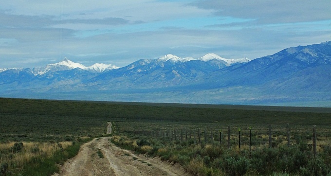 |
|
|
advertisement |
|
|
advertisement |