| |
| |
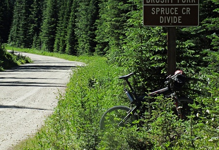
Brushy Fork - Spruce Creek Divide This area of the Bitterroot
Range is a sprawling green forest, with
rocky outcrops, poking their heads above
treeline, like crests of waves in a storm.
And you never know, when you are going to
come upon one of these crests, and when
you will be crawling through the trees the
entire day. There are a few views along
this summit, but they are sparse, and to
be enjoyed when visible, which is not very
long. The north side has an excellent hard
surface perfect for a gravel bike, the
other side not so much. ATVs are not
permitted on this road, even though I saw
two anyway. But all in all, it is a very
quiet ride with barely a car, once you get
over ~5 miles away from US12.
Dayride with this point
as highest summit
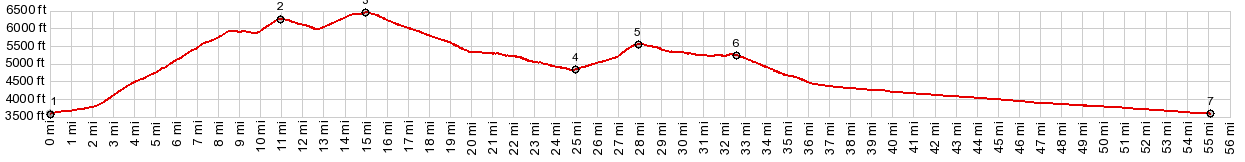
( < FR5621 Como Lake s(u) | FR595 Lolo Pass - Granite Pass > ) Brushy Fork - Spruce Creek Divide , FR373 Spruce Creek(sh) , Lolo Pass: several miles up FR451 Elk Meadows Rd > up Fr451 > Brushy Fork - Spruce Creek Divide > FR373 west > FR373 Spruce Creek Rd s(u) > Lolo Pass <> out and back down west side of Lolo Pass to a turnaround point at the jct of a closed forest road at4740ft >> US12 east > back up FR451 to starting point: 66.1miles with 4610ft of climbing in 5:45hrs (garmin etrex30 m3:20.7.21) Notes: comfortable start and hot return |
 From
South. A sliver of white capped
mountain behind the next obscuring ridge has
been hiding behind the trees, during that
short descend from the state line. Now the
road comes to an edge of this small
plateau and reveals the view. Still - the
higher peaks are mostly hidden from view.
They are behind this carpet of forest fire
matchsticks and beetle kill rot. The long,
straight traverse down to Spruce Creek is
real tour of this burn area. The road passes
numerous turnoffs to now abandoned forest
roads. It reaches a low point before
climbing again towards the FR373 Spruce
Creek summit This side has a rougher surface
and much deeper gravel than the north side,
and I think a mountain bike works better
than a gravel bike.
From
South. A sliver of white capped
mountain behind the next obscuring ridge has
been hiding behind the trees, during that
short descend from the state line. Now the
road comes to an edge of this small
plateau and reveals the view. Still - the
higher peaks are mostly hidden from view.
They are behind this carpet of forest fire
matchsticks and beetle kill rot. The long,
straight traverse down to Spruce Creek is
real tour of this burn area. The road passes
numerous turnoffs to now abandoned forest
roads. It reaches a low point before
climbing again towards the FR373 Spruce
Creek summit This side has a rougher surface
and much deeper gravel than the north side,
and I think a mountain bike works better
than a gravel bike.|
|
advertisement |
|
|
advertisement |