| |
| |
Beaverland Pass This little pass is in the
foothills of the Lost River Range near
Arco. A little rocky in places, the
compensation comes in the form of twisted
limestone cliffs above, and verdant farm
land below, ringed by snow capped
mountains. The name of the pass is used on
several signs along the way.
Past some farm structures and
an ever-so-slight bend in the road, at the
bottom of the wide sage valley, the road
splits twice, for destinations Arco Pass
,Woodland Canyon or Beaverland Pass. Both
intersections are clearly signed. While
traveling up the lower flank of King's
Mountain, an out and back leads to a
trailhead for a nearby arch in the limestone
cliffs. You can clearly see the arch from
the last intersection.But without having
walked up to it and knowing what to look
for, it is almost impossible to recognize it
in the complex pattern of limestone cliffs. A little further up, the road
becomes rocky and steep, but then
unexpectedly crests at a point, where the
northern part of the Lost River Range
(including Mt Borah, the highest point in
Idaho), and the White Knob Mountains to the
west come into view. Near the top tracks in
both directions lead higher.
From
North. (described downwards). ...
nice views of the farmlands surrounding the
Little Lost River, and the white capped
mountain surrounding it. The middle section
is very steep and rocky - impossible to ride
up - not so bad on the way down. At the
beginning of pavement a sign even points up
to the pass, for travelers in the upward
direction.
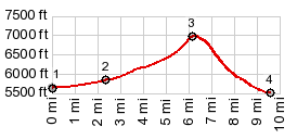
Dayride with this point
as highest summit point
PARTIALLY PAVED / UNPAVED ( < Mt Harrison(ow) | Arco Pass >) Beaverland Pass , additional out and back : Woodland Canyon Rd , a couple of miles up from jct Woodland Cny Rd - Arco Pass Rd > down Woodland Canyon Rd > up Arco Pass Rd > up Sheep Camp Rd <> out and back almost to end of road to Natural Arch Trailhead >> up Sheep Camp Rd > Beaverland Pass > down King Canyon Rd > 3350N Rd south > W2900N Rd east > UW93 south > Arco with sightseeing detours > 2450N Rd east > 2850N Rd north > Arco Pass Rd north > back to starting point on Woodland Canyon Rd : 36.5miles with 2750ft of climbing in 4:16hrs (garmin etrex30 m3:20.6.8, t20_05) Notes: a nice November day during the first part of June. definitely the coldest ride on this trip sofar. The day also included a hike to the end of the Natural Arch trail, halfways up Beaverland Pass. |
|
|
advertisement |
|
|
advertisement |