|
|
|
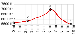
1.START-END WEST: start of Arco Pass Rd,
at a dirt road jc, north east of Arco
2.route to Arco Pass goes right, profile stays left
3.TOP: 7000ft, Beaverland Pass
4.START-END WEST: low point on W33N Rd, where it crosses
King Creek near Moore
|