| |
| |
Old White Bird Hill Rd s(u)
In America the names of many of the
best roads for cycling start with the word "Old".
They date back to a time when roads had a more
harmonic relationship with the landscape. I think
this road is a good example. While the new White Bird
Hill Rd slices along the mountain with a
roadcut, obliterating a good part of it, this road
climbs up in many switchbacks, offering a
multitude of vantage points onto the scenery. This
is one of the few cases when the "Old" road is
still (or again) completely paved. The other major interest along this
road is the White Bird battlefield, from the war
between the Nez Perce Indians and the US army.
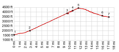
The profile takes that first turnoff. It follows
the river's edge more closely than the new road,
then passing a one land bridge across the Salmon,
old US95 enters the village White Bird from below,
while new US95 sweeps over the top on a bridge.
There is a small general store in town. The road enters a wide grassy bowl, crosses the
White Bird battlefield trail at least twice, and
then gets to work on the grassy slopes. There are
two separate sets of switchbacks. As the climb
progresses, the view reaches further and further
up the chasm carved by the Salmon River, with the
peaks in the Seven Devils area forming tiny
triangles that seem to punctuate the scenery. The
Clearwater Mountains appear as a set ot straight
angular lines culminating in a plateau. Old US95 joins the new road for a short distance
below the new road summit, but then diverges from
it again immediately below the summit. The old
road climbs another 200ft higher, but it seemed
like more than that to me, maybe because of the
additional views. At the top stands quiet in the
lodge in the forest. It may be open, or it may not
be.
From North. (described
downwards). This side is a peaceful, gentle roll
in the forest. Several large houses on large land
allotments are scattered along the way. When the
forest thins out and the valley appears like a
plain below, unpaved "Lake Drive" gives an
opportunity to cut off some distance toward
southbound new US95. Heading towards Grangeville
the old road lasts to within 3 miles of the
village A Dayride with this point as intermediate
summit is on page: Banner Ridge Rd
s(u)
Historical Notes: The Nez Perce War: The first battle in the Nez Perce War was fought at the bottom of northern approach. On June16, 1877, Captain David Perry planned to stop Indians from crossing the Salmon River to safety. The next morning he approached the valley from where now the New White Bird Road runs. The Nez Perce wiped out a third of the Colonel's contingent without suffering any casualties themselves. The Highway: The road over White Bird Hill came into existence because a parallel route through the canyon carved by the Salmon River would be too expensive as a traffic route. That was the conclusion of a railway survey in 1872. The wagon road across the ridge was turned into a highway in 1921, which was part of the road building period following WW1. It was not until 1975 that this road was replaced by the new grade on the other side of the valley. |
|
|
advertisement |
|
|
advertisement |