| |
|
|
|
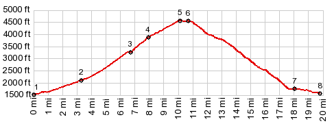
1.(00.0m,1570ft)START-END SOUTH: FR2028 branches of US95 in Salmon River Canyon
2.(03.3m,2090ft)jct with FR463 on right
3.(06.5m,3230ft)route turns left onto Fosket Grade Rd
4.(07.9m,3880ft)route turns right onto Banner Ridge Rd
5.(10.1m,4570ft)TOP
6.(10.7m,4540ft)profile turns left on Free Use rd
7.(18.0m,1840ft)profile turns left on Old White Bird Rd
8.(19.8m,1560ft)START-END NORTH: White Bird (village)
|