| |
| |
La Via del Sale s(u)
There are many
spectacular mountain biking oportunities on top of
the Col de Tende.
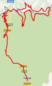
One route that the "Carte de Itineraires VTT" from
the town Tende shows, is the Route du Sel. This is
a loop that ascends Col de Tende and then descends
to the town Tende on a long loop. But when you
start riding it, it becomes apparent that the
Italians were first to put up signs to their
similarly sounding "La Via del Sale". The Via del
Sale is a different route. It is a much shorter
loop that starts and ends on the top of Col de Tende. What I
had planned was the Route du Sel, but what I ended
up doing was La Via del Sale. - Doesn't matter -
any excuse to include some pictures from this
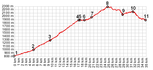
scenically magnificent area. The profile includes
the ascent to the Col de Tende from one side,
followed by the loop of the Via del Sale.
From East 1. Yes - there is a lot of
spectacular scenery here. But the most
historically interesting spot is still the old
fort, just to the east of the pass. I followed
this path past the fort along the ridge. Some
distance after that, still on the ridge line you
arrive at a prominent signed first junction. From
here two roads lead to two higher visible summits.
Following the Italian "La Via del Sale" sign, the
route points towards the right onto French
territory. The French Route "Route du Sel" also
goes right here, even though tere is no sign. The
first switchback happens at Fort Pepin. Here the
routes diverge. The Italian La Via del Sale" makes
a steep switchback, then become a magnificent
climbing single track and crests. Apparently the
"Route du Sel" descends from the Fort directly
into Tende, bypassing the single track and the
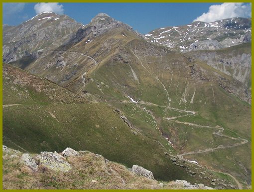
highest portion of the "La Via del Sale". From East 2. (described downwards) From
the summit it is now visible that across towards
the west, a dirt road (really a rock road) climbs
towards Col de la Baovia. The single track track
from the summit we are on, descends to a junction
with this road. Maps label this point Col de
Perle. There is a strong temptation to go right
here, in the belief that this must lead back to
Tende. According to maps this is not the case.
More importantly a "prive" sign forbids entry to
this option. Dayride with this point as
highest summit:
Via de Sale s(u): Tende > Col de Tende > Fort Pepin > Route du Sel s(u) > col de la Perle(shp) <> out and back with turnaround point at col de la Bouria >> Route du Sel > Col de Tende > sp: 37.4 miles with 5690 ft of climbing in 5:34hrs (m4:12.5.30) Notes: the out and back contains a short section of the Ligurische Grenzkammstrasse (=Ligurian border range road). The next pass ride with different start and end
points on this Extended
Tour is: Col de Tende
back to
Cycling Passes in Europe |
 Approaches
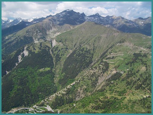
|
|
advertisement |
|
|
advertisement |