| |
|
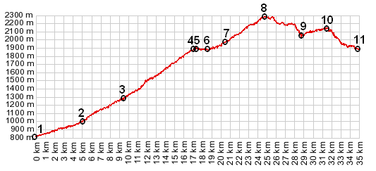
01.(00.0km,817m) START END 1: Tende
02.(05.1km,1000m) Vievola
03.(09.3km,1257m) old Tende Pass road turns off modern road
04.(16.8km,m) START-END 1 ALT: Col du Tende
05.(17.3km,1873m) route goes north around Fort Central
06.(18.4km,1895m) profile goes right at this junction
07.(20.5km,1958m) Fort Pepin, route switches back north
08.(24.6km,2266m) TOP: point of highest altitude on single track trail
09.(28.5km,2081m) Col de Perle, profile turns left onto road
10.(31.4km,2160m) intermediate high point
11.(34.8km,1895m) START-END 2: same as point 6
|