Puerto de Velefique
This is not the highest pass in the
Sierra de Filabres. But it certainly feels that
way. It is also the most scenic climb in that
range, and it has the most cyclists on it. Bikers
who live here like to call it the "Iberian Passo
Stelvio" and the pictures show why.
| I have used the pictures of
panoramio and flickr contributors, as well
as other web sites to illustrate this page.
There are copyright notices and links
to all original pictures. My own pictures
were on a computer, that was stolen at the
train station Frankfurt Airport (model Acer
Aspire One (serial# NUSGPAA01625101C947600F) |
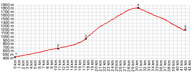 |
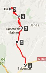
1.(00.0km,0430m)
START-END WEST: Tabernas
2.(10.6km,0680m)road from Alto de Castro
de Filabre joins from left
3.(17.5km,0950m)Velefique
4.(30.4km,1822m)TOP: Puerto de Velefique,
turnoff to Tetica de Bacares
5.(42.0km,1200m)START-END EAST: upper
turnoff to Bacares
|
 Approaches Approaches
From West. A favorite
loop over three summits (this one is the highest)
joins the profile at point 2. The village
Velefique appears as a white line at the base of
slanted green shelf. I hardly see anybody near or
in the conglomeration of white boxes. But there
are plenty of billboard attired cyclists passing
me. The road is covered with regular stretches of
chalk marks for the purpose of racing adulation.
The switchbacks work the road up this inclined
blanket with a constant view of the plain below.
Apparently you can make out the Mediterranean sea
in the far distance from the upper portion of the
road, but in my case the weather does not
cooperate. But yellow wild flowers make a perfect
foreground to the spaghetti road disappearing
below.
Finally the road traverses along the top of a
high valley towards the middle of the range.
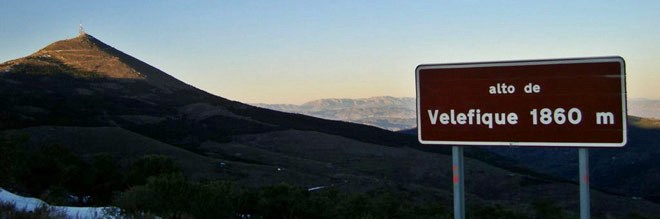
Before getting there a sign anouncing the Alto de
Velefique. This is where most of bike racers turn
around. Cycling traffic from here on is much
lighter, and progress is faster. But the highest
point is not reached until the road reaches an
inconspicuous curve in a grove of trees. Here a
road, as wide as a bikepath, continues a few kms
further up to the transmission facility of the
perfectly cone shaped Tetica Bacares
From East. (described
downwards). The viewshed changes onto a maze of
rounded green hills, the valley floor not yet
visible. Countless dirt tracks thread through the
mixture of loose forest and cultivated land. The
road winds around so much, that it is easy to
loose a sense of direction. My sense was, that the
route turned eastward. But the map shows, that an
overall northerly course is maintained.
On this portion I see a van parked next to the
road. It looks like a sag wagon for cyclists, and
sure enough, that's what it is. The friendly guide
is waiting for the last of a group of German
tourists based out of Almeria, who are cycling the
same day loop as me. He offers me a banana and we
congratulate each other for being able to
experience this incredible day.
And actually the best part of this ride is still
ahead. It lies at the bottom of this narrow
valley. Bacares is more isolated than any of the
other white villages on this loop. Even though
they are occupying the valley bottom, the houses
still seem to vie for the most strategic positions
on rock outcrops over the river. Rolling through
the short section with a business or two, I see
two people carrying groceries, and that's it. The
crossing of Rio Barrancon signals an extreme
change from down to up.
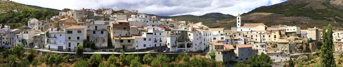
Basares - Copyright Flickr Contributor sergimn piclink
Sidetrip to Tetica de Bacares
I don't see any other people at all on this out
and back climb. From one of the switchbacks
Bacares appears for the first time below. With a
mountain bike all the tracks visible from here
could keep someone busy for a lifetime. The many
tracks stand in contrast to the isolation of this
green mountain carpet. On the last 2 switchbacks
the views disappear, as I climb into a cloud.
There is not much room on top of this perfect cone
shape except the antennas.
SLIDE SHOW
1: Climb to Alto de Velefique
and descend into Bacares
|
|
| cLiCk on image , arrows ,
or thumbnails to advance slideshow |
Dayride with this point as highest summit:
( < Calar
Alto s(u) | Cabo
Cope s(u) > )
Puerto de Velfique , Collado Venta
Luisa s(u) , Alto de
Castro Filabres s(u) , additional out
and back: Gergal > up Al4409 > Alto de
Castro Filabres <> out and back to the top
of Tetica de Bacares > up Al3102 > Puerto de
Velefique > Bacares > Collado Venta Luis
s(u) > Gergal: r5:16.4,5): computer with gps
data was stolen.
Notes: This is a remarkably isolated ride for
Europe. There are places to get water in
Velefique and there appears to be at least one
store in Bacares. But I wouldn't count on
anything being open for getting food or water.
SLIDE SHOW 2: Sidetrip to the
top of Tetica de Bacares
|
|
| cLiCk on image , arrows
, or thumbnails to advance slideshow |
|