| |
| |
Cabo Cope s(u)
The regional park surrounding Cobo Cope is a respite from coastal traffic with great views, with some hiking opportunities. I have no idea where all the previous traffic disappeared to. This little summit on a coastal rockoutcrop of the Costa Blanca came as a complete surprise to me.
Several kms later, somwhere behind Todosol the
traffic disappears. The profile continues on a
small bumpy paved lane into an agricultural area
of liberated vegetables. Here they are not
confined to plastic tarp greenhouses, as I have
become accustomed to seeing, but actually grow
"freely" under the sky. This little road is a
cutoff to the main Rm-D14. It passes a few groups
of houses. A handful of them are clustered around
rural intersections. Then the proifle climbs quite
steeply for a short time to rejoin the main road.
The main road Rm-D14 too now has so little
traffic, that I am wondering if it is actually
open. At the top this is a kind of cape in the dessert,
the viewshed changes from Aguilas to the
Manzanarro area. There are short hiking
opportunities.
From West. (described
downwards). It's a short descend, but extremely
curvy and enjoyable. I take many photos of
abandoned brick buildings on scenic outcrops,
scattered over hill and dale. There is no hint of
what function they once served. Unfortunately I
cannot find pictures of these on the web. Maybe I
should check the flickr group "the art of
decay". Unlucky for me, picturesque decaying
structures are rarely uploaded with geo
coordinates. Included instead are many pictures,
that celebrate the view from the top of this
summit, one or two also a short walking distance
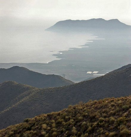
from the road. The summit pictures in the slide shows have
better light than the ones I took. During my visit
the light was more hazy, which seems to be a
common occurrence, at least during spring. My own
pictures resemble the black and white photo in the
slideshow - more or less. I like the foreground in
that shot. Once at the bottom, I pick up the main
road paralleling the 4 lane highway. The concrete
maze with all that coastal traffic returns,
together with a sometimes strange steet pattern.
Exits to roudabouts continue in parallel for a
while, as if the minimize the number of
intersections, but to maximize the kms of built
roads. I haven't seen this road pattern in any
other country.
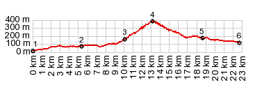
A Dayride with this point as highest summit:
|
|
|
advertisement |
|
|
advertisement |