| |
| |
Collado Venta Luisa
On a satelite map the Collado Venta
Luisa approach looks practically identical to its
counterpart to the west, Puerto de Velefique. The
two summits are very close. But satellite maps
don't tell the whole story. The scenery is very
different over here. The north side of Venta Luisa
stays at a high altitude much longer. In spite of
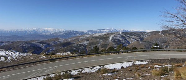
that it is largely a forest ride. But regularly
the road opens up impressive views on the the
world of green slopes below another famous cycling
goal: the Tetica de Bacares on the north side of
Puerto de Velefique. I keep reading about how hot it can
get here. But the three times I rode up the east
side, it rained every time. True to the difference
in climate zones, it always stopped as soon as I
reached the lower foothills and the dessert.
Looking back, the top of this plateau range was
then left open to the imagination, it was obscured
by angry dark clouds.
Looking back from where I came - and about the
only way I can do this here is to just stop -
there are some fine views of Bacares, that look
like I am dropping in on the town with a
parachute. Colado del Ramal is the first
intersection and it is in the trees. The third
road not shown in the profile descends north to
Seron. But the profile turns left to the south. A little
more climbing in moist forest and the trees give
way and show the Tetica Bacares and the road up to
its peak, in proportion to the Sierra de Filabres.
You have to ride this side of the Venta Luisa to
really appreciate the grandeur of the north side
of Puerto de
Velefique. I seem to remember another major paved
intersection between here and the top, but it
doesn't show up on any maps. The top is nothing
more than an intersection in the forest, where a
straight ramp keeps climbing higher to Calar Alto.
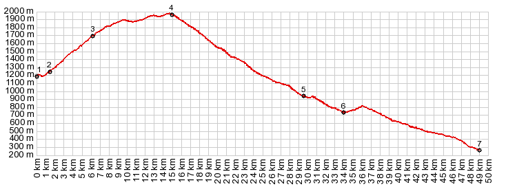
From East. (described
downwards). But this profile heads down. It passes
a mirador, that was shrouded in clouds all three
times that I was up here. After a few majestic
wide sweeping turns along a wide ridge, the road
descends into forest and it is finally warm enough
to stop shivering. The profile shows that you can
descend further than the somewhat derelict
roundabout, just west of Gergal at point 6, even
if this is usually said to be the start of the
climb
I rode this lower portion between points 6
and 7 when I left Gergal. The service road to the
four lane road has no traffic. The surface is
pretty rough and unpredictable, and it crosses
arroyos with steep concrete ramps. Sometimes it
isn't exactly clear weather the through going road
runs north or south of the 4 lane highway. But the
ride is perfectly feasible and I took pictures of
some amazing light conditons in dense coastal fog,
drifting up from the Almeria coast. Unfortunately
those pictures are no longer with me. Dayrides with this point as intermediate
summit are on pages: Calar Alto s(u)
|
|
|
advertisement |
|
|
advertisement |