| |
| |
Tunnel du Morier la Sure
s(u)
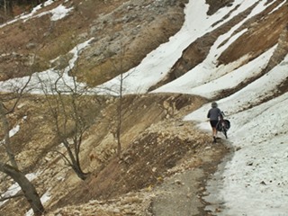
On the map this may look like a
prime road bike route south of Grenoble. But once
on the real thing, it soon becomes obvious that
part of this road has been abandoned. It still is
a feasible bike ride in combination with a walk,
even when there is still snow on the road, as
there was on an Easter Sunday, like when I did
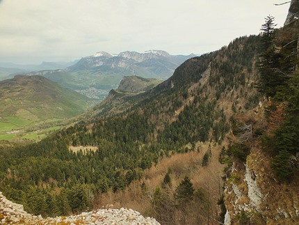
this. ... nice views of Grenoble from above.
Around noon I meet the first cyclist coming the
other way. He tells me, he has about 3km of
carrying his bike through the snow behind him, as
well as a half km dark tunnel. I reconsider and
turn back. But what is this ? Another Easter
Sunday biker is on his way up, and we join
together and head for the snow. It is not deep and
only involves some pushing. Approaching the tunnel
entrance, much of the road along a shelf has been
eroded, and it would take a major construction
project to restore it to a point where a road for
cars could use it. This last section of the climb
heads for a limestone wall, and also has the best
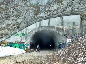
city views below. The tunnel entrance is
completely invisible until you practically stand
in front of it. The tunnel itself is wide, not
lit, but no problem at all to cross. It is
straight, so it never gets completely dark, and it
is definitely less than .5km long.
From South. On the
other side waits a wide paved road, cleared of
snow, and several car loads of people looking to
hike the hills on this holliday. A fast gradual
descend, in a gentle valley leads through a very
laid back ski town landscape. Finally I have to
make a decision weather to continue downhill back
north to Grenoble, or loop south instead, towards
Valence. My daytrip turns left towards Grenoble
here. But this involves crossing another pass: the
Col de la Croix Perin Jaune. So in order to make
the profile as strictly descending as possible,
the profiles turns right and continues to
Villard-de-Lans through the Gorge de la Bourne to
Pont-en-Royans. See the Col de Romeyere
for pictures of that lower section. 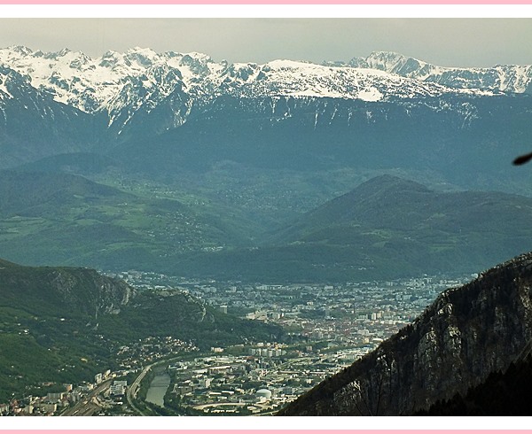 Grenoble through a telephoto lens,
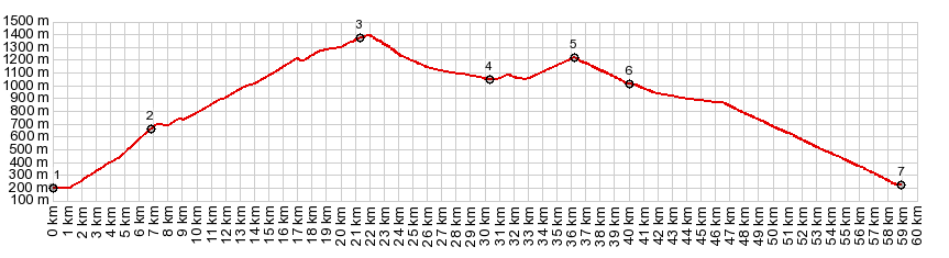
from the upper northern approach Dayride with this point as highest summit: PARTIALLY PAVED / UNPAVED ( < Col du Romeyere | Font d'Urle s(u) > ) Tunnel du Morrier la Sure , Col de la Croix Perrin Jaune: St Gervais le port > Voi Verte des Berges de l"Isere north > Quentin > Montaud > Tunnel du Morier la Sure s(u) > Autrans > Col du Croix Perin Jaune > Lans en Vercors > Sassenage > Quentin > back on Voi Verte des Berges de l'Isere to starting point : 70.2m with 5051ft of climbing in 6:35hrs (r5:19.4.21) |
|
|
advertisement |
|
|
advertisement |