Passo Tremalzo
First something about the lowest
part of the profile : the Ponale Road, Riva del
Garda's most famous mountain biking attraction. -
It is also a hindrance to road bikers. The Ponale
are several miles of old military road that thread
up a cliff south of Riva, under rock overhangs,
between tunnels, through galleries hanging over
the lake, with switchbacks that you can't put
together into a continuous path, when you look
down on them. It's an amazing sight, from afar or
while on it. Much of it is unpaved. It is also the
only way to get a bicycle legally from Riva into
another great cycling region: the Valli Ledro.
This is one of the very few occasions where an
almost 1km long tunnel on the main road is closed
to bicycles. But the tunnel is well lit, and in
reality doesn't present much of a problem in
practice.
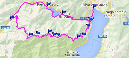
There are several variations to ride to Passo
Tremalzo, but if you start at the bottom for a
loop ride - ie somewhere on Lago di Garda, most of
them are bound to include the Ponale as part of
the loop. (The only exceptions i can think of is
leaving from Tremosine and returning to the south
over Passo San Rocco). So I'll include a
description and pictures of the Ponale here, even
though it could also be on the route for reaching
many lower points. But it's difficult to assign
this road to any particular summit point. I think
most people start loop rides to Passo Tremalzo,
not from the shore of Lago di Garda, but from
further up in the Ledro Valley. This option skips
the Ponale Road.
The Ponale Road
Now to the Passo Tremalzo itself. For me this
is a ride where at the end of the day, it is
hard to remember all the tunnels, all the
sections, the endless turns, views of
switchbacks reaching skywards. I'll try. But I
do remember I walked a lot.
One approach to this pass is what I just
described, the other is paved almost to the top.
The first decision to make is weather to climb
to the top on pavement or on dirt road. My
decision for this was to climb on the dirt part.
Judging from the hundreds of bicycles I saw
going down, I am in the minority.
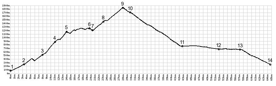 |
1.(80m,00.0km)
START-END EAST 1: southern end of Riva de
Garda, before jct with Ponale.
2.(250m,03.4km) route stays on left bike
path, direction Pregasina
3.(510m,08.0km) Pregasina
4.(881m,11.1km)Bocca De Lanci
5.(1159m,14.0km) Passo Rocchetta
6.(1286m,19.6km) Passo Bestana
7.(1205,20.5km) Rifugio Alpini Passo Nota
8.(1424m,23.2km)Passo Pra Della Rosa
9.(1839m,28.0km)TOP: point of highest
elevation, before Bocca Di Val Marza
10.(1700m,29.8km) Passo Tremalzo
11.(747m,42.6km) Passo Dell'Ampolo
12.(670m,51.9km) profile goes around south
side of Lago Di Ledro on path
13.(670m,57.2km) profile rejoins road east
of Lado Di Ledro
14.(250m,64.6km) START-END SOUTH 2: route
joins other approach on south side of
Ponale |
 Approaches Approaches
From East. Leaving Garda
along the lake heading south, and then looking
back at its plaza facing the lake, you can't help
but turn around and wonder at this space, and if
maybe you shouldn't have lingered just a bit
longer. But the view gets better.
Before the road enters the first short tunnel, a
right leads to the start of the Ponale. The next
few miles have only one thing in common, they
climb and there are lots of mountain bikes on it.
Sometimes the road climbs in a tunnel, sometimes
in a gallery, sometimes the tunnel was paved with
asphalt, sometimes with smooth rocks. At times
there are alternatives to ride around the tunnels.
Below another stripe of asphalt seems in danger of
being rained on by rocks. That road is closed.
Looking back a series of hills grow in perspective
behind Garda. In the background a vertical
mountain capped by a cloud spurrs the imagination.
The Ponale is great for mountain bikers. But it
does not last very long. Also there are two
options. Staying right at a fork leads to the main
road into Ledro Valley, meeting it just after the
tunnel section that is closed to bicycles. Staying
left leads to the road to Pregasina.
The profile follows the latter. At first all road
seem to end in Pregasina. But asking around for
direction Tremalzo, I am sent on a concrete path
climbing above the cemetery. This is a nice place
to climb, and for the moment I was am alone, since
most of the published descriptions seem to send
the crowds along the valley to Molina di Ledro.
But it is nice here above the cemetery. The path
enters a deep forest and the flagstone pavement
with its rough surface is perfect for climbing
standing up. No dirt could give this traction. But
then eventually the road turns to dirt also, and
delivers me to the first point with a view: Bocca
di Lanci at 881 meters. This is view with right
angles, a shoebox with a blue bottom. The sides of
the shoebox have snow on top. A sign here points
to a 1.5km descent into Tremosine. Another sign
comemorates an author of a bicycle magazine who is
said to have made this route to Tremalzo famous.
However - this is not a life like stone statue,
like would be appropriate for the townsquare back
in Riva - just a simple metal plaque.
It's ironic that this plaque would be, not only at
this particular spot, but also helpful. The next
several km (starting after a few hundred meters
from here) are impossible to ride, and without
this plaque about a famous bike route, I would
have definitely concluded that this can't be the
right way. Heaving the bike up over roots and
rocks I finally get it up to Passo Rocchetta
(1159m). I should also mention that apparently
there are two trails between here and Bocca di
Lanci. I took the shallower version, which
involves staying right at a closed inn of sorts,
and then taking the next hard left. My directions
sense is helped along by my gps unit, and I fear
since I have this electronic aid now, I have
probably forgot several junctions along the trail.
But in this case I may have never reached the top
without it.
Passo Tremalzo:
section between Bocca di Lanzi and start of
pavement
A grand surprise stands next to the trail, a hut
selling drinks for many euros each, signed by a
scaregrow with a sign : "Langsam Raststation".
That's not Italian, but people on this end of the
lake don't even try to act Italian anymore,
because they are probably 90 percent visiting
German speakers.
After being reminded how thirsty I was, and
consequently drinking most of my own water (and
resisting the temptation to buy beer or coke -
which really was not so difficult), I quickly
realize a new section is about to get under way.
Passo Rocchetta was the last point directly over
the lake, as if flying above it. The trail now
traverses into a canyon at right angle to the
lake. Its vertical cliffs and zig zag trails
descend into its depths lend it a Himalayan
appearance, especially in the typical hazy of
early afternoon light, that makes judgement of
distance nearly impossible. Somewhere along this
section the published route from Molina must come
up, because nearly every trail section, where
trees break open to reveal the depths below, are
occupied by groups of bikers. Several Inns built
with stone walls so thick they could also be war
fortifications line this path. The path meanwhile
allows for much quicker progress, because of
smoother trail conditions.
The next noticeable pass is Passo Nota - no views,
just a albergo in the woods and a junction with
what must actually be the most direct approach
from this side, and that is an actual road most of
the way from Tremosine. The map also marks a Passo
Bestana before Passo Nota, of which I saw no
indication along the way.
Okay, so after this round about approach to this
point, all Tremalzo bikers should finally be
united in heading for the summit. But I was the
only one on the path - maybe because a
thunderstorm was threatening to break loose. But
for right now, it was just going to collect some
more energy from the atmosphere into a dark somber
blue color, that does not evoke any feelings of
coziness. But then - who knows how long this phase
will last ? I am not going to wait.
In many ways the wilderness games begin all over
again. First a path with a concrete surface
starts. This is ideal for climbing - a sort of
traction carpet. Then the road turns to dirt and
starts the first of three sections of switchbacks,
interspersed with occasional short tunnels,
traversing along limestone spires, that resemble a
hairbrush turned at a 45 degree angle. The first
major tunnel comes into sight, promising a
complete change in viewsheds. Maybe on the other
side the sun will shine. It does not. But it does
reveal the next set of switchbacks.
Looking back down, it is satisfying to see that I
have actually been making some horizontal progress
too. Immediately below are pieces of road like
pieces of spaghetti. But then far off is a long
single spaghetti reaching into the depth of the
valley.
Monte Baldo and its snowcovered peaks on the other
side of the valley float into view above the
tunnel, making it look like a digital overlay. How
can mountains obscured by haze for all this time
appear so detailed ? Apparently the rain did its
job of clearing the athmosphere well, and
thankfully I only got a few drops of it for once.
Exiting the next tunnel, the route continues on a
narrow path between two big piles of snow, and
surprise - who would have thought - that this is
the actual top ? The spot marked as pass on the
maps is still a km or so away and maybe 100 meters
below.
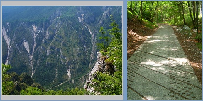
left: climbing avove the Bocca di Lanzi
right: concrete path through the forest between
Pregasine and the Bocca di Lanzi
From West. It does not
become apparent that there is an actual paved road
leading up here until you see the Albergo Tremalzo
and a few motorcycles parked in front of it. The
view to the north west is of mountains with a
rounder appearance, snowcapped non the less, and
with a carpet of high alpine meadows at their
feet. Several high farms also call this home.
This side enters forest quickly. With that the far
views disappear. Descending further a crucifix in
a carefully tended roadside park takes on the
glittering appearance of a jewel just as the sun
comes out. After a long smooth descend on a wide
road with very few cars, the road ends on Passo Ampolo.
Compared with this ride, that spot is just a
nondescript spot along a straight road in a flat
forest with a parking lot next to a hotel.
The profile goes down the Ledro Valley on the main
road, but a separate longer bicycle path exists
along most of the way. It leads around the east
side of the Lago di Ledro, giving great views of
the west side. The main road also is on the west
side. If taking the west side route, bicycle
traffic is finally prohibited on the main road and
detoured below the attractive village Predi. The
profile ends where the route is led back onto the
Ponale, just at the entrance of the long main
tunnel on the main road.
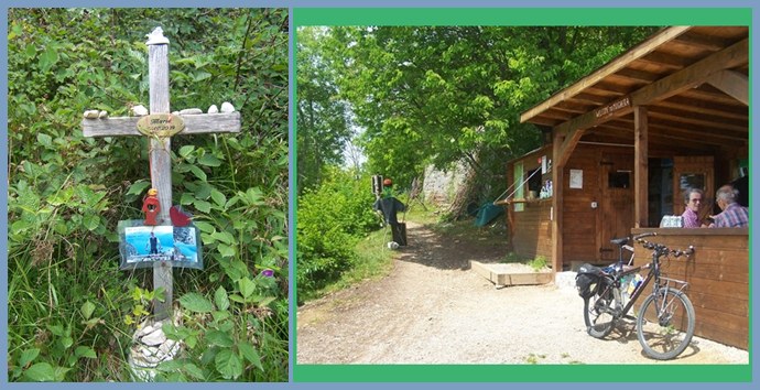
right- the sign reads: Langsam Raststation
left- the last Raststation
Historical Notes:
The Tremalzo Pass Road was built before WW1 for
strategic reasons by Italy. At that time the
border between the Hapsburger Austro-Hungarian
empire and Italy ran along the ridge to the south
of Valle di Ledro. Already before the war there
were many arrests of Italian sympathizers. Towards
the end of 1915 the Ledro Valley was evacuated
entirely. The people were relocated to "Boehmen"
and "Maehren", which was a center for power for
the Hapsburg dynasty. They remained there for
three years, and the Valli de Ledro was completely
destroyed during the war.
Dayride with this point as highest summit:
Passo Tremalzo : Torbole > Riva del
Garda > up Ponale with detours > Pregasine
> Bocca di Lianci > Passo Rocchetta(shp)
> Passo Notta(shp) > Passo Tremalzo >
Passo Ambolo(shp) > down Ledro Valley sometimes
on bike route, sometimes on main road > down
Ponale > Riva del Garda > starting point in
Torbole: 50.5miles with 7339ft of climbing in
6:38hrs (Garmin etrex30 m4:14.6.3).
Notes using the old method this measured
50.1miles with 7034ft of climbing in 6:08hrs
with a VDO MC1.0
The last day with different start and end
points is on page: Passo Lagostrello

|