| |
| |
Tiliacher Joch
Tilianer Joch is an old trading
route between what is now Italy and Austria. It
also played a role in WW1. It is now designated
as an international border crossing mountain
bike route, at least on the Austrian side. Some
large scale maps show the name Ponzescharte at
this location. That is a 400m higher walking
path, that also serves as climbing access. This
is one of the more exciting border crossings and
requires a short push section.
photo page
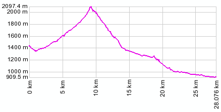
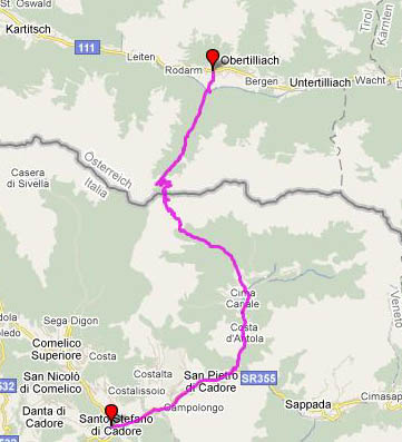
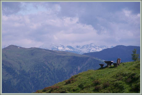
From North. A narrow, paved path heads downhill across the valley from Obertilliach. You can make out the pass from the main road, by visually following a powerline up Obertilliacher valley to below a block shaped mountain, the Ponze at 2599m. The powerline then goes to the right of the block shaped mountain. The Tiliacher Joch goes to the left. The paved path first decends to cross the stream Gailbach. It does so with a few curves to a wooden bridge, passing a cucifix. The path now climbs along along a small mountain stream, intermittently steeply. The surface is smooth crushed, compacted rock/dirt, that drains so well that it is usually dry even it rained cats and dogs the night before. The mountain Ponce intermittently appears between the trees. I is possible to meet a slow moving tractor or car on the path, which carries supplies to a hut. The path passes a high lake with a first building. This is not the (hut) Ponzehuette. Here the trees thin out. Now sharp switchbacks make their way up above treeline towards the Ponzehuette. A very short distance below this second hut a large sign points the way left to the "international border crossing mountain bike route" over the Tiliacher Joch. More switchbacks, this time on a rougher single track follow. You cross a gate, which designates the next section as "Schiebestrecke" (push your bike route), and five minutes later voila the summit. A hiking path following along the top of the range, also leading to the Ponze Scharte (2363m) crosses at the summit. The difference in the views to north and south is striking. To the south are dolomite needles, while to the north the more normally behaved Carniche alps may be hidden in clouds.
It seems like passes in the dolomites often have
two parts. The first is the alpine part, followed
by a relaxing roll through the forest. Only
afterwards comes the second part, another large
descent into a deep canyon. This is the case here
too. A cracked, heaving, sloughing, innumerable
patched up road descends into a crack in the
earth, a needle of a rock towering above. The road
follows the valle Visdende to its junction with a
main road. Turning right here the descent
continues intermittently to the town of Campolongo
and San Stefano. The church at the main plaza has
an interesting mural of some hellish scene from
the bible. Turn right to go up paved Kreuzbergpass
(pso di Monte Croce di Comelico).
Dayride.
PARTIALLY PAVED / UNPAVED Tilliacher Joch , Kreuzberg Pass , Kartitscher Sattel: Obertilliach > up the north side to Tilliacher Joch > down the south side > Campolongo > Kreuzbergpass > Innichen (S Candido) > Sillian > Kartitscher Sattel > sp: 66 miles with 7000ft of climbing in 6:5 hours (VDO MC1.0 m3:9.6.21). The last day with different start and end points on this Extended Tour is on page: Ploeckenpass History
During the middle ages a feudal boundary ran along the river in the Lesachtal on the Austrian side. Following a power dispute, the border was moved to the top of the ridge. However Italian speaking people from the south retained grazing rights and brought their cows over this pass to graze on what is now the Austrian side. When Italy declared war on Austria in 1914, WW1 was also fought here. Rifle comandoes kept Italians at bay against shrapnel and burning granades, but the village of Obertillian was vacated. In order to affect the outcome the poeple of Obertillian vowed to worship and pray and dedicated a new local holiday for June 19 (called Herz Jesu Freitag). The holiday was set up to expire after 20 years, but local authorities have decided to extend the expiration date regularly to this date, which explains why all the stores were closed when I happened to get here.
|
||||||||||||||||||||||||||||||||||||||||||||
 Approaches
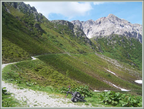
|
|
advertisement |
|
|
advertisement |