| |
| |
Luchon-Superbagneres(ow)
The old spa town Luchon must be one
of the most inspiring towns, amongst those that
play a big part along the route of theTour de
France. With this town as an anchor point, riders
race over Col de
Peyresourde and Col de Portalet, and others.
Sometimes the race also includes a climb to the
ski area, named Superbagneres, above the old spa
town. The road is steep and scenically
sensational, but even more important - it is wide,
well paved and all the turns have a fairly wide
radius. And perhaps even more important that that:
On top of Superbagnere is a super large parking
lot, that can easily accommodate a train of
entourages. Luchon itself stands in contrast to
that. It is a charming little spa town with a
wonderful main street. The buildings and arcades
of old trees frame the mountain views at every
street crossing. In my mind, I am sure, that the
main street was oriented for the perfect view of
the mountains above (although I am still only
guessing).
And after that the scenery gets interesting, so
there is no more reason to just climb for pain's
sake. By the time the road reaches the junction
with the valley road to Cascade d'Envers, the size
of the monumental amphitheater of mountains, that
the road will attempt to climb out of, is clear.
It does so with large far flung switchbacks, that
allow for a fast trip when coming back down. The monumental hotel at the top appears like a
fortress to capitalism. Up close it doesn't look
quite as well preserved, especially with the
concrete addition, or is that the servants
quarters ? Everything is mothballed in the summer,
including the mini golf course. Out behind the
hotel waits a great reciprocal view of the
cemetery in Bangere de Luchon. It is the best
vantage point onto the mountains from the village.
And from up here all the graves are discernible
through a good telephoto lens. The first ski lift station is hardly much higher
than the hotel, and is reachable on a dirt track.
There are multiple ways down with a mountain bike.
But my objective was to get a little higher on
foot, since it was a very hot day. This road
summit is perfect for that. An alpine trail leaves
direction several sanctuaries, just past the first
lift station to the north.
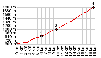
Pictures from the hike from the ski station are here Dayride with this one-way point as highest summit, and no two way summit points: PARTIALLY PAVED / UNPAVED ( < Col de Mente | Col de Portet > ) Superbagnere(ow): Bagneres de Luchon <> Superbagnere(ow) <> GR4 trailhead: 23.9miles with 4360ft of climbing in 3:13hrs (garmin etrex30 r5:19.5.31) Notes: day also included a hike from turnaround point to peak at 2380m (7808ft). Climbing while walking: 546m~1791ft; total climbing: 6151ft - the first mountain day with absolutely perfect weather - the only unpaved part in the ride is the sort section from the ski station to the trailhead. 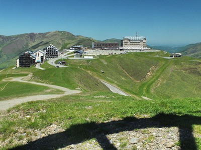 History Historythe resort: the resort was already opened in the early 20th century. Apparently a rack and pinion railway was first used to get to the top. I saw no signs or reminders of this along the way anywhere. Cycling - Tour de France : The climb to the top of the ski area was included in the Tour de France the first time in 1961, the first of 6 stages that all ended on top of the mountain. 1961 was also the longest day of those 6 stages. The stage started in Toulouse and went over 208km.1986 also was a long stage, that started in Pau and ended on top of the mountain 186km later. It was Greg Lemond's first Tour de France stage win, and he managed to win it with more than a minute between him and the next competitor. |
|
|
advertisement |
|
|
advertisement |