| |
| |
Col de Mente
After climbing up the south side and
seeing the crowds at this summit without views,
this was not one of my favorites, even though
there really was nothing to complain about. But
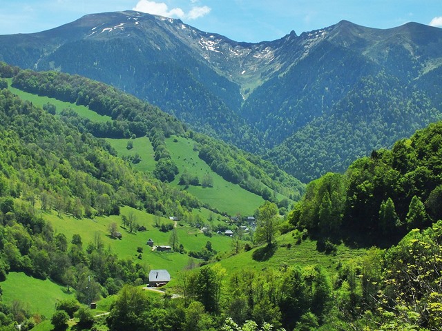
the northern approach with all its switchbacks,
ramps and big green presence across the valley
completely changed my mind.
But back to the pass. After quite a workout this
turns out to be a one view pass. The view toward
the vestiges of higher peaks to the north happens
during the last series of switchbacks. The top has
no view, but a bar/restaurant with a huge parking
lot, filled to overcrowding with any and all kinds
of bikers and other motorists.
From North. (described
downwards) This side is quite a bit more
interesting. Ramps connected by switchbacks lead
into the depths of a green valley. I meet dozens
of cyclists coming the other way, and not a single
motorist amongst them - the opposite seen as at
the summit bar. The imposing green fluted
mountain, growing bigger by the switchback, is Pic
de Escales, 1816 meters. The last village clinging
to the v shaped green slot in the earth is Soulan.
From there it's just a couple of tight switchbacks
to shifting from last to first, because on the
other side is steep but short climb.. The road follows the wild mountain stream through
the forest downhill. There are no immediate paved
connections between here and the world south. At
the junction with the road to Portet d'Aspet the
profie goes left instead and continues generally
downhill. following a stream in a deep green
valley to the jct of D618 with D5 to Aspet.
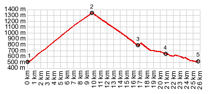
 Dayride with this point a highest summit: COMPLETELY PAVED ( < Port de Bales | Superbagnere(ow) > ) Col de Mente , Col des Ares , Col de Burel , additional out and backs : Bagneres de Luchon > Cierp-Gaud > St Beat > Col de Mente <> out and back to La Mourtia ski station >> Soulan <> jct with rd to Plan du Rey <> out and back back to Soulan <> separate out and back to Portillon > Col de Burel > Juzet s'Izaut > Col des Ares > Chaum > back to starting point in Bagneres de Luchon with grocery shopping detour: 67.1miles with 6804ft of climbing in 6:29hrs (garmin etrex30 r5:19.5.30) Notes: this was not the planned route. But the paved connection between Plan de Rey and Col d'Articasgou, shown on the Michelin 1:200000 maps does not exist. The connection between La Mourtia ski station and the same pass does not seem to exist either. 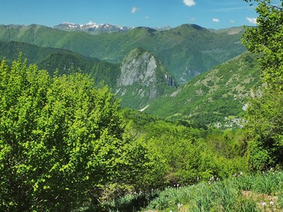 History HistoryCycling - Tour de France: This summit has been part of a Tour de France stage 18 times between 1966 and 2018, making this one of the most popular summits with the route planners. While by far the most popular anchor point for such a stage is (Bagneres de) Luchon, all of the stages have had a different route and the other anchor point have been distant places like Carcasonne (216km), Pau (214km) or Toulouse |
|
|
advertisement |
|
|
advertisement |