| |
| |
Col de Portet(ow)
This is a famously steep and
difficult Tour de France climb in the high
Pyrenees. Both sides are French, yet the north
side has no road. Pavement stops at the top.
Though it would be interesting to know if you can
get a mountain bike down the other side to make a
loop ride.
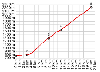
The climbing continues. Just when I thought I had
just a little more than enough, a cyclist came
speeding and screaming down the road yelling
advice, that it is about to become easier for me.
And sure enough, looking at the profile just
before reaching point 4, there is a stretch with
with a discernibly smaller slope - even when seen
in context of the whole profile, it's barely worth
mentioning. But the descending cyclist had good
advice - sure enough, approaching the junction
with the road to Plateau d'Adet and its mammoth
ski station city, there is time for a rest -
relatively speaking.
Switchbacks above treeline slowly work themselves
towards the obvious gap above. The infamous tunnel
near the top is really just a short ski overrun.
In spite of this it is fairly dark inside. There
is an easy trail around it, that does not take
longer than 2 minutes. Once you get to the pass, even for the last 10
meters before reaching it, all you see in front is
the racing graffiti. The remnants of pavement of
the road are still between you and the view on the
other side. A final steep push reveals new
mountains to the west. A far reaching tundra
plateau to the north invites for a hike. A short
spur road to the north leads into these high
rolling hills. The obvious hiking goal is Mt
Pichalay[2626m], or one of the knobs in the chain
leading up to it.
From South. From the
top of the pass you can see a dirt road reaching
down maybe 50 meters to service a ski lift. No
roads are visible further below. The map shows a
trail connecting with a spur from the "Lakes
Road". I have no experience with it.
Dayride with this point as highest one way summit (and over no 2 way summit): PARTIALLY PAVED / UNPAVED ( < Superbagnere(ow) | Col d'Azet > ) Col de Portet(ow): Vielle Aure <> Col de Portet[ow] <> turnaround point on short spur from summit north, with detour in village on way back: 28.8miles with 4985ft of climbing in 3:42hrs (garmin etrex30 r5:19.5.2) Notes: the only unpaved part is the short spur at the summit. From there the day also included a hike not quite reaching nearby [Mount] Pichaley in a roundabout way (2626m). hiking(h) and biking(b) statitstics below h+b: max-min=8383ft-2556ft=5827ft, 33.8mies with 6588ft of climbing in 6:06hrs h only: max-min=8377-7002=1375, 4.1miles with 1634ft of climbing in 2:10hrs History Cycling - Tour de France: The reason I saw so much racing graffiti on the upper part was not, because it has such a long history as a Tour de France climb, but because it was on the itinerary so recently. The summit was included for the first time in 2018. It was only 65 km, but also included Col d'Azet and Col de Peyresourde, and of course it ended on top of the Col de Portet. The rider arriving on top first, arrived with no other rider visible behind him. However - the lower part of the profile, leading also to the ski station at Plateau d'Adet has been used 10 times, between 1974 and 2014. Naturally these stages also finished on top, and the ski station certainly has more room for all those racing crew caravans and multiple entourages than Col de Portet. The longest of these stage started in Andorra and was 230 km long, another La Seu d'Urgell in Spain with a length of 209km. 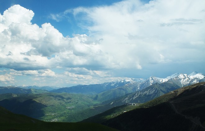 |
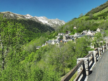 But the profile leads up the
harder of the two roads, and the second part of
the climb is about to start. From here on, the
road is rougher and rocks somewhere on the road
are the rule, not the exception. The road does its
best to climb out of this high valley, limiting
the view on two sides. But in the end, the road
doesn't do much more than keep up with the
climbing valley floor. In the back is where the
vista is - very dramatic on the way back with late
light.
But the profile leads up the
harder of the two roads, and the second part of
the climb is about to start. From here on, the
road is rougher and rocks somewhere on the road
are the rule, not the exception. The road does its
best to climb out of this high valley, limiting
the view on two sides. But in the end, the road
doesn't do much more than keep up with the
climbing valley floor. In the back is where the
vista is - very dramatic on the way back with late
light.|
|
advertisement |
|
|
advertisement |