| |
| |
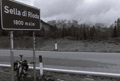
Sella di Razzo / Sella di Rioda s(u) This summit is made up of
rolling high mountain meadows, framed by
stunning peaks. Three paved roads meet
here, forming at least two separate high
points. However the named landmarks here
are not topographical summits but
"sellas", the mountain meadows. A point
just before Sella di Rioda (signed at
1780m) seems to be the highest point
of all these three meeting roads. There is
a sign there, but it is not marked on any
of the maps I have seen. Instead my map
labels the same point as Sella di Razzo.
However I seem to remember a sign placing
Sella di Razza (signed at 1760m) past the
junction and the highest point on the
profile. The last mentioned point has the
best views on all the serrated edges,
surrounding the scene for 270 degrees. The approach from the east
is a ride with several sections of very
different character.
The last tunnel emerges at the
shore of a reservoir, and the other approach
over a pass joins in from across the dam and
another tunnel. Next along the climb are the
vaccation towns Sauris di Sotto and
Sauris di Sopra (lower and upper
Sauris). The sturdy wooden houses crowding
around a church have a somewhat Germanic
look to them. Further on, the road keeps on
climbing, across from a serrated cone,
shrouded partly by clouds. Eight numbered
switchbacks constitute the steepest part of
the climb, and the road seems undecided just
if it wants to go above treeline or not in
this angular valley.
From
West. (described downwards). At the
junction just past the high point, both
directions go generally downhill. This
profile takes the left over another signed
sella, Sella di Razzo. At 1760 meters
(according to the sign) it is slightly lower
than the summit. But this is the spot with
the best views, especially with the light I
had. Then past the Sella di
Campigotto (1790m) the far views give way to
switchbacks in deep forest. Once in a while
a peak in the upper field of view disrupts
the green peace. Below are more
strategically placed vacation towns, amongst
them Lorenzago di Cadore, where big
rectangles of stately vacation lodges line
up between the soccer field below and the
serrated ridges above. From here there is a
way to cut over to the base of Passo di Maurio.
This is what I did for my dayloop below. But
the profile continues on down into the
valley of the Piave to show a maximum of
elevation gain.
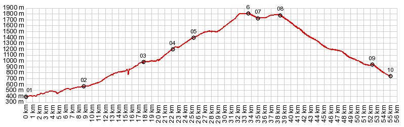
Dayride with this point
as highest summit:
COMPLETELY PAVED ( < Cesta Na Mangart | Passo della Pura > ) Sella di Razzo s(u) , Passo della Mauria: Ampezzo > up SP73 > Sauris di Sotto > Sauris di Sopra > Sella di Razzo s(u) > Sella Campigotto(shp) > Vigo di Cadore > Lorenzago di Cadore > Passo della Mauria > Forni di Soprs > Forni di Sotto <> detour around a tunnel that turned out to be closed [the detour was closed, not the tunnel] > back to starting point in Ampezzo: 57.7m with 7100ft of climbing in 6:13hrs (garmin etrex30 r5:21.9.22) 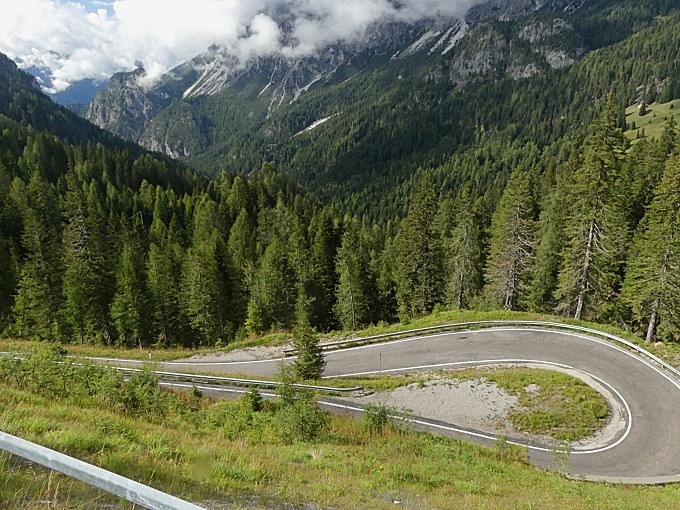 |
 The top section
are several gentle high alpine meadows. Each
Sella is named and they are fairly close in
height and location. The highest point turns
out to be a point slightly before the sign
anouncing Sella di Razzo. There is a
picturesque bench there, perfect for gazing
at the serrated ridge across the valley
The top section
are several gentle high alpine meadows. Each
Sella is named and they are fairly close in
height and location. The highest point turns
out to be a point slightly before the sign
anouncing Sella di Razzo. There is a
picturesque bench there, perfect for gazing
at the serrated ridge across the valley|
|
advertisement |
|
|
advertisement |