| |
| |
Cesta na Mangart(ow) Defensive border roads in
the mountains of Europe are always
something special. Safety concerns are
thrown to the wind, when it comes to
defending yourself from your neighbor in
the next world war (at least as far as the
previous world wars are concerned). Here
the result is a narrow, exposed road with
sheer drop offs. But the surface is kept
in excellent condition. From the top,
Slovenians have a choice spot to see
what's happening below in Italy. The road
is popular with cyclists (on my ride
probably around 100), motorcyclists (maybe
~200), climbers and car tourists. It is
amazing how they all get by each other on
this narrow road with sheer drop offs. -
This is the highest paved road in Slovenia
external slide show with pictures from this page +addtional external slide show of a hike from the top of the cycling summit
The objective of this climb
comes into the center field of view right
after the turnoff. It's that large mountain,
shaped like a coin stuck into the ground. A
few high traverses can be seen. But exactly
where below the mountain top the road ends
is not clear yet.
Dayride without two way
summits and this point as highest one way
summit:
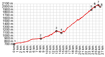
COMPLETELY PAVED ( < Vrsic Pass | Sella di Razzo s(u) > ) Fusine <> Tarviso <> Cave del Predil with sightseeing detour <> Passo Predil(shp) << loop at end of road below M Mangari: 44.4miles with 5460ft of climbing in 5:24hrs (garmin etrex30 r5:22.9.14) Notes: hike from top point to forcella Mangart (2166m) gained about 450ft from end of ride. Elev_max - elev_min, including walking = 7050ft -2360ft = 4690ft History WW2: The road was built by Italian soldiers in 1938, when the area was Italian. Building it took two years, and did not stop during winter. Then, after WW2, the border between Italy and Yugoslavia was in dispute. Occupational troops were on both sides. The 10th Mountain Division, trained in Colorado, played this role for the Allied side. An informational tablet along the route tells how they set up a ski race in June 1945, won by a certain Walter Prager, who went on to become the coach of the US Olympic Ski team in 1948. 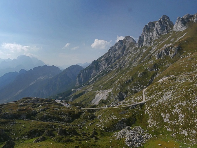 |
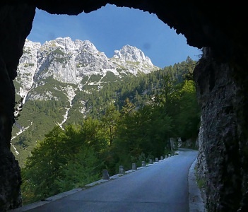 For now the road
just alternates between tight switchbacks in
the forest and short, unlit tunnels, with
just enough light in them, that they can be
ridden even without a light. One ~600m
tunnel is long enough to present a
completely new viewshed at the exit. The
road finally climbs above treeline and the
vertical limestone texture walls give way to
a tundra landscape, bordered by steep
cliffs. That coin shaped mountain has not
changed much in the meantime. Cars parked
not far above hint, that the road will not
be open much higher. However with a bicycle
that's a good thing, and the road, now
converted into a hiking trail with bike
access, gains the last hundred meters in
open tundra. At the top is a one way loop,
that does not gain enough elevation to make
this a two way summit. A short walk from the
top leads to views down to the Fusine lakes.
A very popular route to the top of Mangart
Peak starts here. Firsty it's a rocky hike
and then it turns more and more into a real
climb. Since it starts so high there there
can be an enormous number of people on the
mountain at the same time.
For now the road
just alternates between tight switchbacks in
the forest and short, unlit tunnels, with
just enough light in them, that they can be
ridden even without a light. One ~600m
tunnel is long enough to present a
completely new viewshed at the exit. The
road finally climbs above treeline and the
vertical limestone texture walls give way to
a tundra landscape, bordered by steep
cliffs. That coin shaped mountain has not
changed much in the meantime. Cars parked
not far above hint, that the road will not
be open much higher. However with a bicycle
that's a good thing, and the road, now
converted into a hiking trail with bike
access, gains the last hundred meters in
open tundra. At the top is a one way loop,
that does not gain enough elevation to make
this a two way summit. A short walk from the
top leads to views down to the Fusine lakes.
A very popular route to the top of Mangart
Peak starts here. Firsty it's a rocky hike
and then it turns more and more into a real
climb. Since it starts so high there there
can be an enormous number of people on the
mountain at the same time.|
|
advertisement |
|
|
adverti |