| |
| |
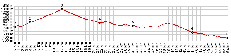
Passo della Mauria This is one of the bigger
roads into the dolomites from the south,
but still more bikable than the heavily
tunneled roads to the east. On a Friday in
September I had virtually no traffic on
this exceptionally smooth road, not to
mention the not so smooth mountain ridges
in the upper field of view.
From
South. (described downwards). There
are few switchbacks on this side too. But
mostly this is a fast descent. The bicycle
makes quick progress on the map, not like Sella di
Razzo on the other side of the
mountain, where there just is not enough
room on the map to include all those
switchbacks. The tourist towns on this side
Forni "di Sopra" and "di lower" make a very
relaxed impression. Below Forni di Sotto the
road enters a 2.2km long tunnel. The old way
on the right, through several shorter
tunnels is closed after several km. Before
reaching Ampezzo one more small workout is
required to get over a point almost big
enough to be called a summit in its own
right. Entering Ampezzo from this side gives
this town with its boxed together housing
the most medieval appearance, compared with
all the other towns along this loop.
A Dayride with this point
as intermediate summit is on page: Sella di
Razzo s(u)
|
|
|
advertisement |
|
|
advertisement |