| |
| |
Pso. di San Osvaldo
The Friulli dolomites along pso
di San Osvaldo may not be quite as high, and the
canyons may not have as many precipitous steps as
the ones of the Bellunesi dolomites. But this pass
has other things going for it. It is a great
cycling routes because of less traffic and two
picturesque, sedate towns along its eastern
approach. Also, there is little chance to get lost
since this a (for the alps) relatively long route
with few cul de sacs up side valleys.
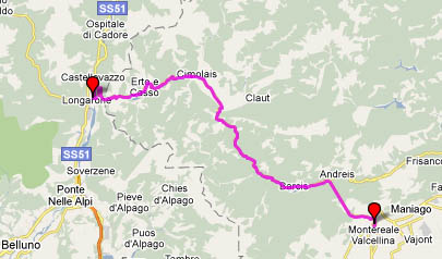 Approaches Approaches
From West. From Longarone you cross
the wide braided river Piave and head north. The
road climbs partially up the limestome plateau
with long regular ramps. It enters a one way
gallery type tunnel with a red-green interval of 8
minutes. From the gallery openings are great views
downvalley of Langarone. Where the tunnel emerges,
the road turns into a damned low canyon. From here
a rolling hill route leads to the town of Erto. A
cycling / pedestrian path before the town turns
out to have a short 20 percent grade and leads to
the lower part of the town, where you have to
carry the bike up stairs to get back on the road,
not exactly the most efficient route, but
picturesque nontheless. All businesses, such
as an alimentari, are in the new part of town
which is above the main road. Leaving Erto the
road traverses under a high cliff around a lake,
enters a high valley and finds a low saddle at the
end of a high valley for the descent. No ski
areas, hotels or souvenir shops on top of this
pass.
From East. (described downwards) There
are a few forested switchbacks. But the road soon
enters a gradually sloping valley that is as easy
to ride down as it is easy on the brake pads of a
fully loaded mountain bike. A long gradual descent
leads through the easy going tourist town of
Cimolais. Turning south the road enters a deep
canyon and several long tunnels, culminating in a
3750m long tunnel with ear deafening ventilators
on both ends. They are well lit and of course open
to bicycles. This is a good descend in the rain.
You stay dry. If already wet when entering the
tunnel, the ventilors help dry out, if you can
stand the noise. This last tunnel emerges on a
half kilometer long, low bridge over another
damned lake. A few more curves and the road
reaches the southern end of the mountains in
Maniago, where it becomes apparent that this is
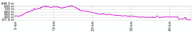
the sountern end of the dolomites. A day on a tour:
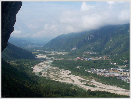
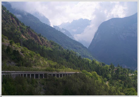
(<Pso di San Pelegrino|Vrsic Pass>) Pso di San Osvaldo: Longarone > Pso di San Osvaldo > small roads of Friuli to San Daniele: 66 miles with 3400ft of climbing in 6:2 hours (VDO MC1.0 m3:9.5.10), Notes: This included an extraordinarily long and difficult room search in San Daniele . From here the ride continued over valley roads to the Slovenian town of Kobarid. picture locations. 1:
Piave river valley from tunnel gallery above
Longarone 2: another gallery on the eastern side
below Erto.
|
||||||||||||||||||||||||||||||||||||||||||||||||||||||||||||||
|
|
advertisement |
|
|
advertisement |