| |
|
|
|
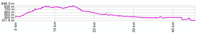
01.(km00, 440m) START-END WEST: Longarone
02.(km10+1/2,790m) Erto e Casso
03.(km14+1/2,827m) TOP: Pso di San Osvaldo
04.(km17,670m) Simolais
05.(km21,550m) turnoff to Pinedo on left
06.(km38,470m) Parpiero
07.(km45+1/2,320m) START-END EAST: Montereale Valcellina, west of Maniago
|
|
elevation profile before point 7 is wrong due to a tunnel